|
OCEANOLOGY
& OCEANOGRAPHY
Please use our
A-Z to
navigate this site or return HOME
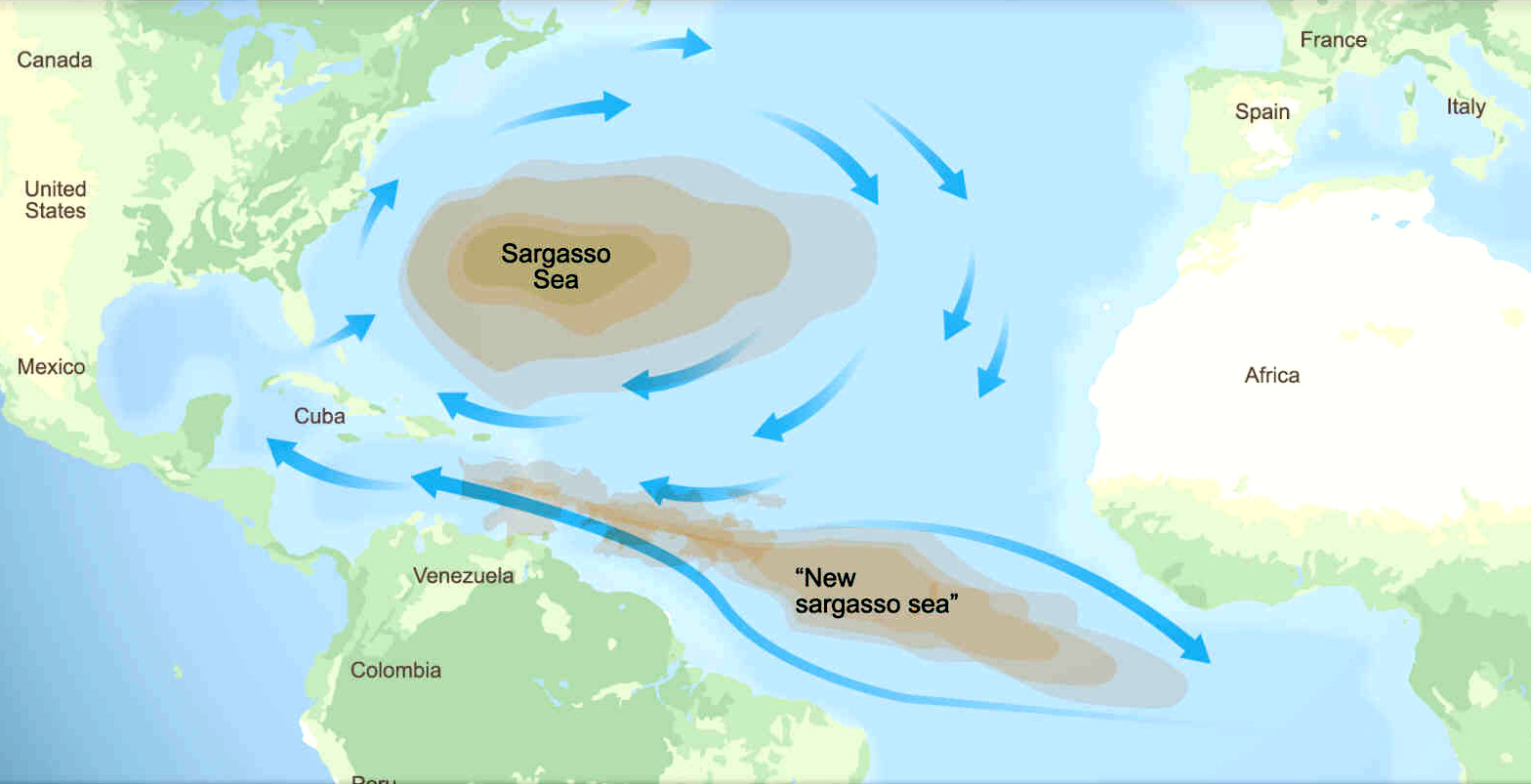
SARGASSUM
- The giant brown seaweed, having shown that it can spread
from North to South Atlantic oceans, could spread to the
Indian and Pacific oceans as a potentially invasive species.
The proof of which (as a theory) is satellite pictures, and
changing wind states. The spread witnessed here, could just as
easily migrate between oceans, and thence to the bays and seas
within those oceans.
Oceanology is an area of Earth Science that deals with
oceans. Oceanology, also called as Oceanography, is a vast subject covering a range of topics in the sub field areas of Physical, Chemical, Biological and Geological oceanography.
Oceanography is an interdisciplinary science that studies the oceans and seas of the world. It covers a wide range of topics including the ever-dynamical interactions in the marine ecosystem, plate tectonics, seabed geology, and ocean currents. Fundamentally, oceanography goes hand in hand with physics, chemistry, mathematics, biology, and geology.
MARINE BIOLOGY
marine biology, is the study of marine life, right from microplanktons to plants and animals in the oceans and saltwater environments. In reality, marine biology is closely related to oceanography, and to have a full understanding of marine biology, it is important to have some knowledge of oceanography.
Marine Biology’s range is quite broad; specializations can be based on a single species, family, behavior, or ecosystem. For example, marine biologists may choose to study a single species of fish or all fish varieties that are native to a climate or region.
Like oceanography, marine biology is also interdisciplinary where cellular biology, chemistry, ecology, geology, meteorology, botany, genetics, molecular biology, physical and biological oceanography, and zoology intersect.
PHYSICAL OCEANOGRAPHY
Studies ‘why’, ‘where’, and ‘how’ waves, tides, and currents work. Physical oceanographers look into the interaction of the ocean with the atmospheric factors including temperature, salinity, density, wind speed, tides, eddies, and gyres. They also seek answers to coastal erosion,
ocean circulation, and fluid motion. Physical mechanisms responsible for sea ice and polar ice sheet distribution are also the focus area of the physical oceanographers.
Physical Oceanography is further divided into Descriptive and Dynamical Physical Oceanography. Descriptive Oceanography studies the ocean through numerical models and fluid motions. While Dynamical Physical Oceanography deals with the motion of fluids and ocean currents.
BIOLOGICAL OCEANOGRAPHY
It is the study of the ocean through the lens of marine life, its distribution, abundance, environmental interaction, and predation. Biological Oceanographers look into the processes that lead to the unique behavioral and reproductive patterns of marine organisms. They will also study the ocean’s chemical makeup and ecology to better understand relationships in the oceans. Any sudden shift in the chemical profile of the ocean has a profound effect on its inhabitants.
Biological oceanography is similar to marine biology, but they are distinct and should not be conflated.
CHEMICAL OCEANOGRAPHY
It studies ocean chemistry. It is a field that is very much in the exploratory phase. Chemical
oceanography can be further divided into marine chemistry (studies the concerned with chemical constituents of seawater) and marine geochemistry (studies geological processes, the chemistry of ocean floor, and the role of microbes in the formation or alteration of the ocean’s geology.
Ocean chemistry provides a window into the origin and evolution of marine life, chemical mass balance, ocean sediments, and climate. Chemical oceanographers’ majorly look into ocean acidification and its effect on ecology and the influence of changing geology and biological activity in the ocean. They also collaborate with biological and physical oceanographers to study human-induced marine pollution and to protect and preserve the marine ecosystem.
GEOLOGICAL OCEANOGRAPHY
Also referred to as geophysical oceanography, Geological Oceanography is the study of the ocean floor and many interesting formations under the water – mountains, volcanoes canyons, and valleys. For example, the Mid-Ocean Ridge, the longest continuous mountain chain on the
planet is a hot research topic among geological oceanographers.
Stretching over 40,000 miles (mostly underwater), the Mid-Ocean Ridge is a divergent plate boundary and it represents one of the most important geologic phenomena that shaped the earth.
The results of geological oceanographic studies also help us understand and evaluate future societal issues including global warming.
EARLY HISTORY
Humans first acquired knowledge of the waves and currents of the seas and oceans in pre-historic times. Observations on tides were recorded by Aristotle and Strabo in 384-322 BC. Early exploration of the oceans was primarily for cartography and mainly limited to its surfaces and of the animals that fishermen brought up in nets, though depth soundings by lead line were taken.
The Portuguese campaign of Atlantic navigation is the earliest example of a systematic scientific large project, sustained over many decades, studying the currents and winds of the Atlantic.
The secrecy involving the Portuguese navigations, with the death penalty for the leaking of maps and routes, concentrated all sensitive records in the Royal Archives, completely destroyed by the Lisbon earthquake of 1775. However, the systematic nature of the Portuguese campaign, mapping the currents and winds of the Atlantic, is demonstrated by the understanding of the seasonal variations, with expeditions setting sail at different times of the year taking different routes to take account of seasonal predominate winds. This happens from as early as late 15th century and early 16th: Bartolomeu Dias followed the African coast on his way south in August 1487, while Vasco da Gama would take an open sea route from the latitude of Sierra Leone, spending 3 months in the open sea of the South Atlantic to profit from the southwards deflection of the southwesterly on the Brazilian side (and the Brazilian current going southward) - Gama departed in July 1497); and Pedro Alvares Cabral, departing March 1500) took an even larger arch to the west, from the latitude of Cape Verde, thus avoiding the summer monsoon (which would have blocked the route taken by Gama at the time he set sail).
Furthermore, there were systematic expeditions pushing into the western Northern Atlantic (Teive, 1454; Vogado, 1462; Teles, 1474; Ulmo, 1486). The documents relating to the supplying of ships, and the ordering of sun declination tables for the southern Atlantic for as early as 1493–1496, all suggest a well-planned and systematic activity happening during the decade long period between Bartolomeu Dias finding the southern tip of Africa, and Gama's departure; additionally, there are indications of further travels by Bartolomeu Dias in the area. The most significant consequence of this systematic knowledge was the negotiation of the Treaty of Tordesillas in 1494, moving the line of demarcation 270 leagues to the west (from 100 to 370 leagues west of the Azores), bringing what is now Brazil into the Portuguese area of domination. The knowledge gathered from open sea exploration allowed for the well-documented extended periods of sail without sight of land, not by accident but as pre-determined planned route; for example, 30 days for Bartolomeu Dias culminating on Mossel Bay, the 3 months Gama spent in the South Atlantic to use the Brazil current (southward), or the 29 days Cabral took from Cape Verde up to landing in Monte Pascoal, Brazil.
The Danish expedition to Arabia 1761-67 can be said to be the world's first oceanographic expedition, as the ship Grønland had on board a group of scientists, including naturalist Peter Forsskål, who was assigned an explicit task by the king, Frederik V, to study and describe the marine life in the open sea, including finding the cause of mareel, or milky seas. For this purpose, the expedition was equipped with nets and scrapers, specifically designed to collect samples from the open waters and the bottom at great depth.
Although Juan Ponce de León in 1513 first identified the Gulf Stream, and the current was well known to mariners, Benjamin Franklin made the first scientific study of it and gave it its name. Franklin measured water temperatures during several Atlantic crossings and correctly explained the Gulf Stream's cause. Franklin and Timothy Folger printed the first map of the Gulf Stream in 1769–1770.
Information on the currents of the Pacific Ocean was gathered by explorers of the late 18th century, including James Cook and Louis Antoine de Bougainville. James Rennell wrote the first scientific textbooks on oceanography, detailing the current flows of the Atlantic and Indian oceans. During a voyage around the Cape of Good Hope in 1777, he mapped "the banks and currents at the Lagullas". He was also the first to understand the nature of the intermittent current near the Isles of Scilly, (now known as Rennell's Current).
Sir James Clark Ross took the first modern sounding in deep sea in 1840, and Charles Darwin published a paper on reefs and the formation of atolls as a result of the second voyage of HMS Beagle in 1831–1836. Robert FitzRoy published a four-volume report of Beagle's three voyages. In 1841–1842 Edward Forbes undertook dredging in the Aegean Sea that founded marine ecology.
The first superintendent of the United States Naval Observatory (1842–1861), Matthew Fontaine Maury devoted his time to the study of marine meteorology, navigation, and charting prevailing winds and currents. His 1855 textbook Physical Geography of the Sea was one of the first comprehensive oceanography studies. Many nations sent oceanographic observations to Maury at the Naval Observatory, where he and his colleagues evaluated the information and distributed the results worldwide.
MODERN OCEANOGRAPHY
Knowledge of the oceans remained confined to the topmost few fathoms of the water and a small amount of the bottom, mainly in shallow areas. Almost nothing was known of the ocean depths. The British Royal Navy's efforts to chart all of the world's coastlines in the mid-19th century reinforced the vague idea that most of the ocean was very deep, although little more was known. As exploration ignited both popular and scientific interest in the polar regions and Africa, so too did the mysteries of the unexplored oceans.
The seminal event in the founding of the modern science of oceanography was the 1872–1876 Challenger expedition. As the first true oceanographic cruise, this expedition laid the groundwork for an entire academic and research discipline. In response to a recommendation from the Royal Society, the British Government announced in 1871 an expedition to explore world's oceans and conduct appropriate scientific investigation. Charles Wyville Thompson and Sir John Murray launched the Challenger expedition. Challenger, leased from the Royal Navy, was modified for scientific work and equipped with separate laboratories for natural history and chemistry. Under the scientific supervision of Thomson, Challenger travelled nearly 70,000 nautical miles (130,000 km) surveying and exploring. On her journey circumnavigating the globe, 492 deep sea soundings, 133 bottom dredges, 151 open water trawls and 263 serial water temperature observations were taken. Around 4,700 new species of marine life were discovered. The result was the Report Of The Scientific Results of the Exploring Voyage of H.M.S. Challenger during the years 1873–76. Murray, who supervised the publication, described the report as "the greatest advance in the knowledge of our planet since the celebrated discoveries of the fifteenth and sixteenth centuries". He went on to found the academic discipline of oceanography at the University of Edinburgh, which remained the centre for oceanographic research well into the 20th century. Murray was the first to study marine trenches and in particular the Mid-Atlantic Ridge, and map the sedimentary deposits in the oceans. He tried to map out the world's ocean currents based on salinity and temperature observations, and was the first to correctly understand the nature of coral reef development.
In the late 19th century, other Western nations also sent out scientific expeditions (as did private individuals and institutions). The first purpose built oceanographic ship, Albatros, was built in 1882. In 1893, Fridtjof Nansen allowed his ship, Fram, to be frozen in the Arctic ice. This enabled him to obtain oceanographic, meteorological and astronomical data at a stationary spot over an extended period.
In 1881 the geographer John Francon Williams published a seminal book, Geography of the Oceans. Between 1907 and 1911 Otto Krümmel published the Handbuch der Ozeanographie, which became influential in awakening public interest in oceanography. The four-month 1910 North Atlantic expedition headed by John Murray and Johan Hjort was the most ambitious research oceanographic and marine zoological project ever mounted until then, and led to the classic 1912 book The Depths of the Ocean.
The first acoustic measurement of sea depth was made in 1914. Between 1925 and 1927 the "Meteor" expedition gathered 70,000 ocean depth measurements using an echo sounder, surveying the Mid-Atlantic Ridge.
In 1934, Easter Ellen Cupp, the first woman to have earned a PhD (at Scripps) in the United States, completed a major work on diatoms that remained the standard taxonomy in the field until well after her death in 1999. In 1940, Cupp was let go from her position at Scripps. Sverdrup specifically commended Cupp as a conscientious and industrious worker and commented that his decision was no reflection on her ability as a scientist. Sverdrup used the instructor billet vacated by Cupp to employ Marston
Sargent, a biologist studying marine algae, which was not a new research program at Scripps. Financial pressures did not prevent Sverdrup from retaining the services of two other young post-doctoral students, Walter Munk and Roger Revelle. Cupp's partner, Dorothy Rosenbury, found her a position teaching high school, where she remained for the rest of her career.
(Russell, 2000)
Sverdrup, Johnson and Fleming published The Oceans in 1942, which was a major landmark. The Sea (in three volumes, covering physical oceanography, seawater and geology) edited by M.N. Hill was published in 1962, while Rhodes Fairbridge's Encyclopedia of Oceanography was published in 1966.
The Great Global Rift, running along the Mid Atlantic Ridge, was discovered by Maurice Ewing and Bruce Heezen in 1953 and mapped by Heezen and Marie Tharp using bathymetric data; in 1954 a mountain range under the Arctic Ocean was found by the Arctic Institute of the USSR. The theory of seafloor spreading was developed in 1960 by Harry Hammond Hess. The Ocean Drilling Program started in 1966. Deep-sea vents were discovered in 1977 by Jack Corliss and Robert Ballard in the submersible DSV Alvin.
In the 1950s, Auguste Piccard invented the bathyscaphe and used the bathyscaphe Trieste to investigate the ocean's depths. The United States nuclear submarine Nautilus made the first journey under the ice to the North Pole in 1958. In 1962 the FLIP (Floating Instrument Platform), a 355-foot (108 m) spar buoy, was first deployed.
In 1968, Tanya Atwater led the first all-woman oceanographic expedition. Until that time, gender policies restricted women oceanographers from participating in voyages to a significant extent.
From the 1970s, there has been much emphasis on the application of large scale computers to oceanography to allow numerical predictions of ocean conditions and as a part of overall environmental change prediction. Early techniques included analog computers (such as the Ishiguro Storm Surge Computer) generally now replaced by numerical methods (eg SLOSH.) An oceanographic buoy array was established in the Pacific to allow prediction of El Niño events.
1990 saw the start of the World Ocean Circulation Experiment (WOCE) which continued until 2002. Geosat seafloor mapping data became available in 1995.
Study of the oceans is critical to understanding shifts in Earth's energy balance along with related global and regional changes in climate, the biosphere and biogeochemistry. The atmosphere and ocean are linked because of evaporation and precipitation as well as thermal flux (and solar insolation). Recent studies have advanced knowledge on ocean acidification, ocean heat content, ocean currents, sea level rise, the oceanic carbon cycle, the water cycle, Arctic sea ice decline, coral bleaching, marine heatwaves, extreme weather, coastal erosion and many other phenomena in regards to ongoing climate change and climate feedbacks.
In general, understanding the world ocean through further scientific study enables better stewardship and sustainable utilization of Earth's resources.
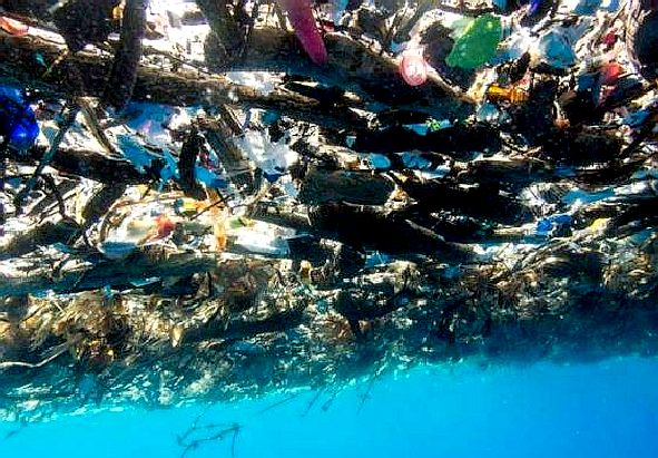
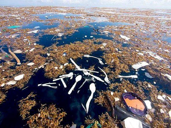
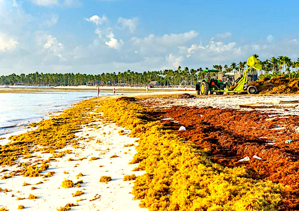
PLASTIC
TIDE - These amazing pictures of a giant plastic tide were
taken by Caroline Power. Please note how plastic and sargassum
intertwine, creating a separation problem.
LINKS
& REFERENCE
http://www.
AEGEAN
- ACIDIFICATION
- ADRIATIC
- AMBRACIAN
GULF
- ARCTIC
- ATLANTIC
- BALTIC
- BAY
BENGAL - BAY
BISCAY - BERING
- BLACK
- CARIBBEAN
- CASPIAN
- CORAL
- EAST
CHINA SEA
ENGLISH
CH - GOC
- GUANABARA
- GULF
GUINEA - GULF
MEXICO - INDIAN
-
IRC - IONIAN - IRISH
- MEDITERRANEAN
- NORTH
SEA - PACIFIC
- PERSIAN
GULF - SEA
JAPAN
STH
CHINA - PLASTIC
- PLANKTON
- PLASTIC
OCEANS - RED
- SARGASSO
- SEA
LEVEL RISE - SOUTHERN - TYRRHENIAN
- UNCLOS
- UNEP
- WOC
- WWF
This
website is provided on a free basis as a public information
service. copyright © Cleaner
Oceans Foundation Ltd (COFL) (Company No: 4674774)
February 2025. Solar
Studios, BN271RF, United Kingdom.
COFL
is a charity without share capital. The names Amphimax™
RiverVax™
and SeaVax™
are trademarks.
|