|
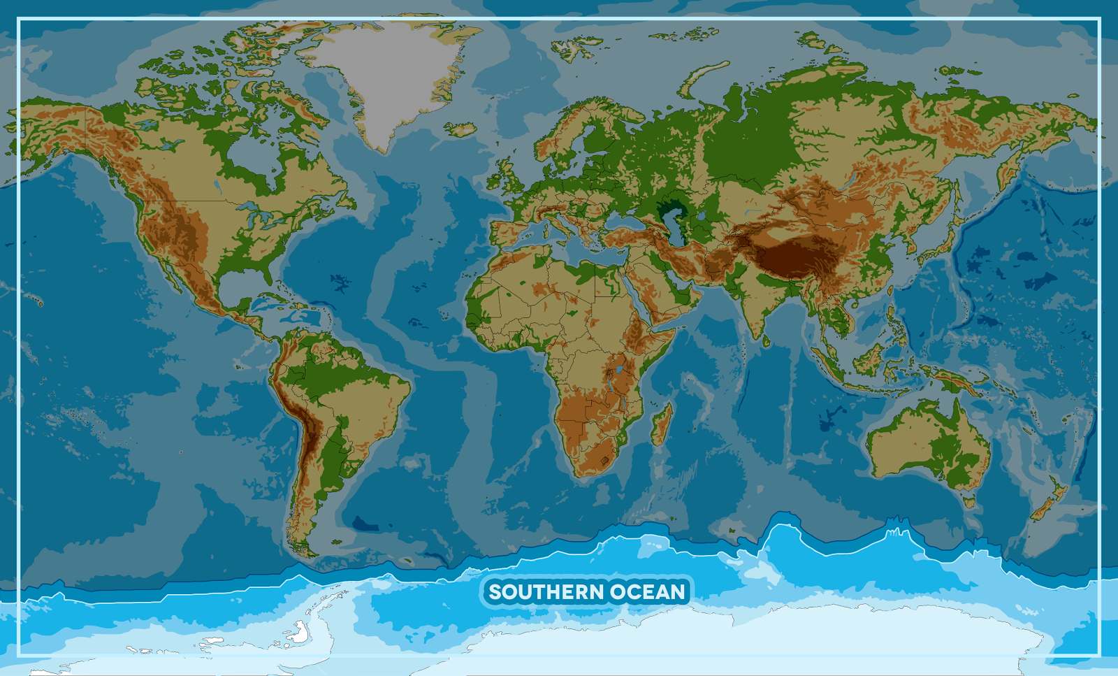
SOUTHERN
OCEAN
ABOUT -
CLIMATE
CHANGE - CONTACTS - DONATE
- FOUNDATION -
HOME - OCEAN
PLASTIC
Please
use our A-Z INDEX
to navigate this site
THE
INDEPENDENT FEB 2015 - Scientists estimate that about 8 million tons of plastic debris such as food packaging and
plastic bottles
are being washed into the oceans each year – and the cumulative quantity of waste will result in a tenfold increase in the total amount of plastic in the sea by 2020.Orca
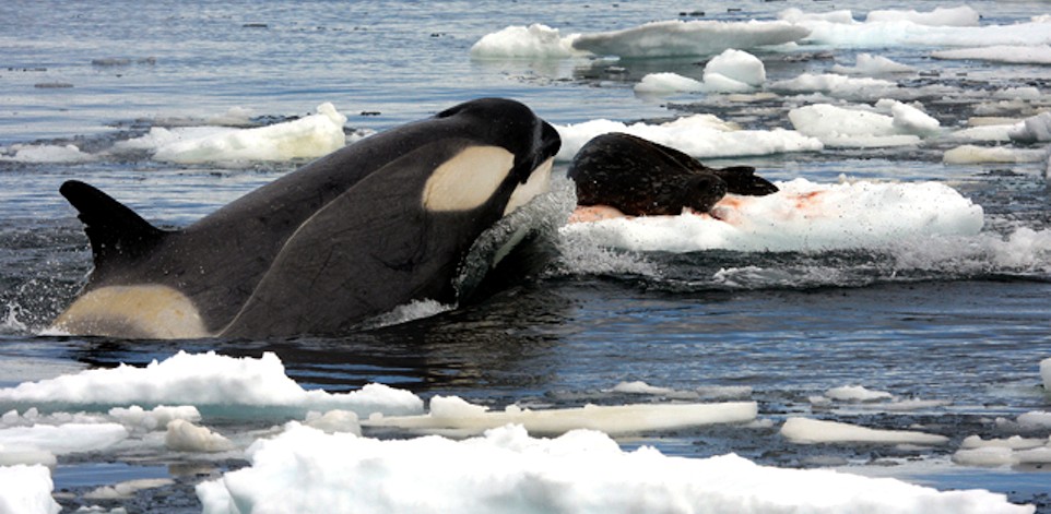
(Orcinus orca) hunting a Weddell seal in the Southern Ocean.
The Southern Ocean, also known as the
Antarctic Ocean or the Austral Ocean, comprises the southernmost waters of the World Ocean, generally taken to be south of 60° S latitude and encircling Antarctica. As such, it is regarded as the fourth-largest of the five principal oceanic divisions: smaller than the Pacific, Atlantic, and Indian Oceans but larger than the Arctic Ocean. This ocean zone is where cold, northward flowing waters from the Antarctic mix with warmer subantarctic waters.
The Southern Ocean was formed when Antarctica and South America moved apart, opening the Drake Passage, roughly 30 million years ago. The separation of the continents allowed the formation of the Antarctic Circumpolar Current.
With a northern limit at 60°S, the Southern Ocean differs from the other oceans in that its largest boundary, the northern boundary, does not abut a landmass (as it did with the first edition of Limits of Oceans and Seas). Instead, the northern limit is with the Atlantic, Indian and Pacific Oceans.
One reason for considering it as a separate ocean stems from the fact that much of the water of the Southern Ocean differs from the water in the other oceans.
Water gets transported around the Southern Ocean fairly rapidly because of the Antarctic Circumpolar Current which circulates around Antarctica. Water in the Southern Ocean south of, for example,
New
Zealand, resembles the water in the Southern Ocean south of South America more closely than it resembles the water in the Pacific Ocean.
The Southern Ocean has typical depths of between 4,000 and 5,000 m (13,000 and 16,000 ft) over most of its extent with only limited areas of shallow water. The Southern Ocean's greatest depth of 7,236 m (23,740 ft) occurs at the southern end of the South Sandwich Trench, at 60°00'S, 024°W. The Antarctic continental shelf appears generally narrow and unusually deep, its edge lying at depths up to 800 m (2,600 ft), compared to a global mean of 133 m (436 ft).
Equinox to equinox in line with the sun's seasonal influence, the Antarctic ice pack fluctuates from an average minimum of 2.6 million square
kilometres (1.0×10⁶ sq mi) in March to about 18.8 million square kilometres (7.3×10⁶ sq mi) in September, more than a sevenfold increase in area.
BIODIVERSITY
A variety of marine animals exist and rely, directly or indirectly, on the phytoplankton in the Southern Ocean. Antarctic sea life includes penguins, blue whales, orcas, colossal squids and fur seals. The emperor penguin is the only penguin that breeds during the winter in Antarctica, while the Adélie penguin breeds farther south than any other penguin. The rockhopper penguin has distinctive feathers around the eyes, giving the appearance of elaborate eyelashes. King penguins, chinstrap penguins, and gentoo penguins also breed in the Antarctic.
The Antarctic fur seal was very heavily hunted in the 18th and 19th centuries for its pelt by
sealers from the United States and the United Kingdom. The Weddell seal, a "true seal", is named after Sir James Weddell, commander of British sealing expeditions in the Weddell Sea. Antarctic
krill, which congregates in large schools, is the keystone species of the ecosystem of the Southern Ocean, and is an important food organism for whales, seals, leopard seals, fur seals,
squid, icefish, penguins, albatrosses and many other
birds.
The benthic communities of the seafloor are diverse and dense, with up to 155,000 animals found in 1 square metre (10.8 sq ft). As the seafloor environment is very similar all around the Antarctic, hundreds of species can be found all the way around the mainland, which is a uniquely wide distribution for such a large community. Deep-sea gigantism is common among these animals.
A census of sea life carried out during the International Polar Year and which involved some 500 researchers was released in 2010. The research is part of the global Census of Marine Life (CoML) and has disclosed some remarkable findings. More than 235 marine organisms live in both polar regions, having bridged the gap of 12,000 km (7,456 mi). Large animals such as some
cetaceans and birds make the round trip annually. More surprising are small forms of life such as mudworms, sea cucumbers and free-swimming snails found in both polar oceans. Various factors may aid in their distribution – fairly uniform temperatures of the deep ocean at the poles and the equator which differ by no more than 5 °C, and the major current systems or marine conveyor belt which transport egg and larva stages.
OCEAN
AWARENESS CAMPAIGN - As
part of the Cleaner Ocean Foundation's ocean
literacy campaign, we are developing a game that can be
played on mobile devices like the iphone or android smart
phones. In this game children learn a little about geography
as they select one of five ocean areas to rid of marine
litter. The screen above shows that the player has selected
the Southern Ocean to tackle. Copyright Map © January 29 2018
all rights reserved COF
Ltd. Copyright Maps © January 29 2018
all rights reserved COF
Ltd.
CAPTAIN
JAMES COOK
By way of his voyages in the 1770s,
Captain James Cook proved that waters encompassed the southern latitudes of the globe. Since then, geographers have disagreed on the Southern Ocean's northern boundary or even existence, considering the waters part of the Pacific, Atlantic, and Indian Oceans, instead. This remains the current official policy of the International Hydrographic Organization (IHO), since a 2000 revision of its definitions including the Southern Ocean as the waters south of the 60th parallel has not yet been adopted. Others regard the seasonally-fluctuating Antarctic Convergence as the natural boundary.
The obsession of the undiscovered continent culminated in the brain of Alexander Dalrymple, the brilliant and erratic hydrographer who was nominated by the Royal Society to command the Transit of Venus expedition to Tahiti in 1769. The command of the expedition was given by the admiralty to Captain James Cook. Sailing in 1772 with Resolution, a vessel of 462 tons under his own command and Adventure of 336 tons under Captain Tobias Furneaux, Cook first searched in vain for Bouvet Island, then sailed for 20 degrees of longitude to the westward in latitude 58° S, and then 30° eastward for the most part south of 60° S, a lower southern latitude than had ever been voluntarily entered before by any vessel. On 17 January 1773 the Antarctic Circle was crossed for the first time in history and the two ships reached 67° 15' S by 39° 35' E, where their course was stopped by ice.
Cook then turned northward to look for French Southern and Antarctic Lands, of the discovery of which he had received news at Cape Town, but from the rough determination of his longitude by Kerguelen, Cook reached the assigned latitude 10° too far east and did not see it. He turned south again and was stopped by ice in 61° 52′ S by 95° E and continued eastward nearly on the parallel of 60° S to 147° E. On 16 March, the approaching winter drove him northward for rest to New Zealand and the tropical islands of the Pacific. In November 1773, Cook left
New
Zealand, having parted company with the Adventure, and reached 60° S by 177° W, whence he sailed eastward keeping as far south as the floating ice allowed. The Antarctic Circle was crossed on 20 December and Cook remained south of it for three days, being compelled after reaching 67° 31′ S to stand north again in 135° W.
A long detour to 47° 50′ S served to show that there was no land connection between New Zealand and Tierra del Fuego. Turning south again, Cook crossed the Antarctic Circle for the third time at 109° 30′ W before his progress was once again blocked by ice four days later at 71° 10′ S by 106° 54′ W. This point, reached on 30 January 1774, was the farthest south attained in the 18th century. With a great detour to the east, almost to the coast of South America, the expedition regained Tahiti for refreshment. In November 1774, Cook started from New Zealand and crossed the South Pacific without sighting land between 53° and 57° S to Tierra del Fuego; then, passing Cape Horn on 29 December, he rediscovered Roché Island renaming it Isle of Georgia, and discovered the South Sandwich Islands (named Sandwich Land by him), the only ice-clad land he had seen, before crossing the South Atlantic to the Cape of Good Hope between 55° and 60°. He thereby laid open the way for future Antarctic exploration by exploding the myth of a habitable southern continent. Cook's most southerly discovery of land lay on the temperate side of the 60th parallel, and he convinced himself that if land lay farther south it was practically inaccessible and without economic value.
Voyagers rounding Cape Horn frequently met with contrary winds and were driven southward into snowy skies and ice-encumbered seas; but so far as can be ascertained none of them before 1770 reached the Antarctic Circle, or knew it, if they did.
In a voyage from 1822 to 1824, James Weddell commanded the 160-ton brig Jane, accompanied by his second ship Beaufoy captained by Matthew Brisbane. Together they sailed to the South Orkneys where sealing proved disappointing. They turned south in the hope of finding a better sealing ground. The season was unusually mild and tranquil, and on 20 February 1823 the two ships reached latitude 74°15' S and longitude 34°16'45″ W the southernmost position any ship had ever reached up to that time. A few icebergs were sighted but there was still no sight of land, leading Weddell to theorize that the sea continued as far as the South Pole. Another two days' sailing would have brought him to Coat's Land (to the east of the Weddell Sea) but Weddell decided to turn back.
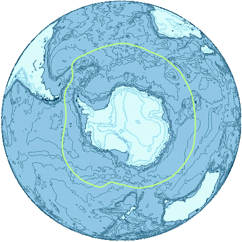
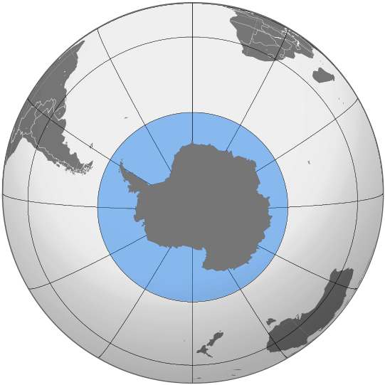
[LEFT] A general delineation of the Antarctic Convergence, sometimes used by scientists as the demarcation of the Southern Ocean. [RIGHT] The Southern Ocean, as delineated by the draft 4th edition of the International Hydrographic Organization's Limits of Oceans and Seas (2002).
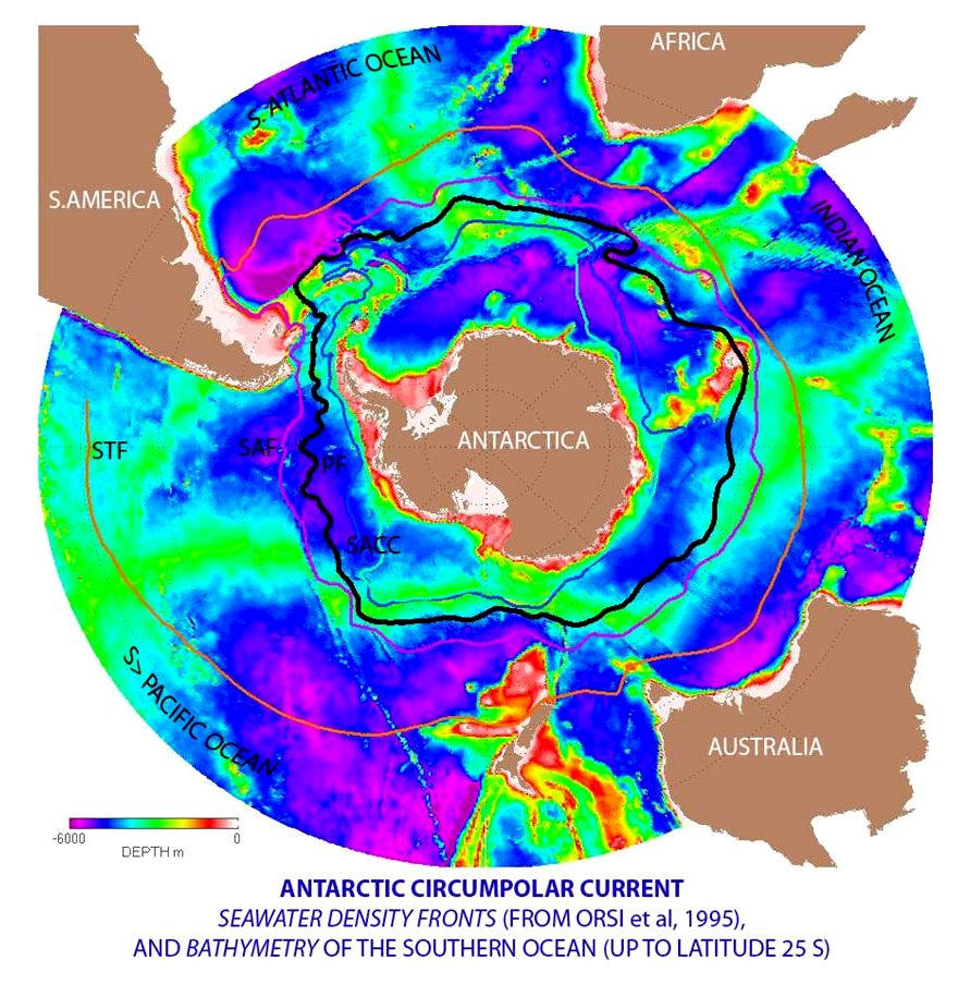
CIRCUMPOLAR CURRENT CONVERGENCE - The Antarctic Circumpolar Current moves perpetually eastward
chasing and joining itself, and at 21,000 km (13,000 mi) in length
it comprises the world's longest ocean current, transporting 130 million cubic metres per second (4.6×10⁹ cu ft/s) of water.
This is 100 times the flow of all the world's rivers.
Several processes operate along the coast of Antarctica to produce, in the Southern Ocean, types of water masses not produced elsewhere in the oceans of the Southern Hemisphere. One of these is the Antarctic Bottom Water, a very cold, highly saline, dense water that forms under sea ice.
Associated with the Circumpolar Current is the Antarctic Convergence encircling Antarctica, where cold northward-flowing Antarctic waters meet the relatively warmer waters of the subantarctic, Antarctic waters predominantly sink beneath subantarctic waters, while associated zones of mixing and upwelling create a zone very high in nutrients. These nurture high levels of phytoplankton with associated copepods and Antarctic krill, and resultant foodchains supporting fish, whales, seals, penguins, albatrosses and a wealth of other species.
The Antarctic Convergence is considered to be the best natural definition of the northern extent of the Southern Ocean.
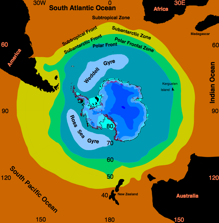
ROSS & WEDDELL GYRES - The Ross Gyre and Weddell Gyre are two gyres that exist within the Southern Ocean. The gyres are located in the Ross Sea and Weddell Sea respectively, and both rotate clockwise. The gyres are formed by interactions between the Antarctic Circumpolar Current and the Antarctic Continental Shelf.
Sea ice has been noted to persist in the central area of the Ross Gyre. There is some evidence that global warming has resulted in some decrease of the salinity of the waters of the Ross Gyre since the 1950s.
Due to the Coriolis effect acting to the left in the Southern Hemisphere and the resulting Ekman transport away from the centres of the Weddell Gyre, these regions are very productive due to upwelling of cold, nutrient rich water.
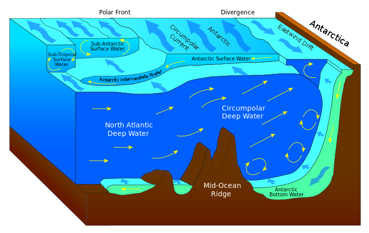
UPWELLING - Large-scale upwelling is found in the Southern Ocean. Strong westerly (eastward) winds blow around Antarctica, driving a significant flow of water northwards. This is actually a type of coastal upwelling. Since there are no continents in a band of open latitudes between South America and the tip of the Antarctic Peninsula, some of this water is drawn up from great depths. In many numerical models and observational syntheses, the Southern Ocean upwelling represents the primary means by which deep dense water is brought to the surface. Shallower, wind-driven upwelling is also found off the west coasts of North and South America, northwest and southwest Africa, and southwest and southeast Australia, all associated with oceanic subtropical high pressure circulations.
Some models of the ocean circulation suggest that broad-scale upwelling occurs in the tropics, as pressure driven flows converge water toward the low latitudes where it is diffusively warmed from above. The required diffusion coefficients, however, appear to be larger than are observed in the real ocean. Nonetheless, some diffusive upwelling does probably occur.
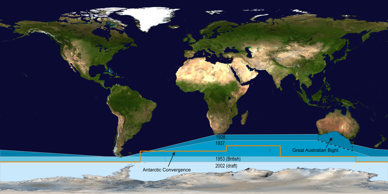
DELINEATION
- The International Hydrographic Organization's delineation of the "Southern Ocean" has moved steadily southwards since the original 1928 edition of its Limits of Oceans and Seas. Australia continues to view the ocean as beginning at its southern coast. The 1953 limits shown are those of Britain, as identified in third edition. Others continue to view the Antarctic Convergence as the natural boundary of the Southern Ocean, regardless of political agreements.

SINKING
- The
MS Explorer in Antarctica in January 1999. She sank on 23 November 2007 after hitting an iceberg.
LINKS
& REFERENCE
https://en.wikipedia.org/wiki/Southern_Ocean
http://news.nationalgeographic.com/news/2015/01/150109-oceans-plastic-sea-trash-science-marine-debris/
http://www.independent.co.uk/environment/plastic-waste-in-ocean-to-increase-tenfold-by-2020-10042613.html
ABS
- ACID
OCEANS - BIOMAGNIFICATION
- BP DEEPWATER - CANCER
- CARRIER BAGS
- CLOTHING - COTTON BUDS - DDT
FISHING
NETS
-
FUKUSHIMA - MARINE LITTER
- MICROBEADS
- MICRO
PLASTICS - NYLON - OCEAN GYRES
- OCEAN WASTE
PACKAGING - PCBS
-
PET - PLASTIC
- PLASTICS
- POLYCARBONATE
- POLYSTYRENE
- POLYPROPYLENE - POLYTHENE - POPS
PVC - SHOES
- SINGLE USE
- STRAWS - WATER
AEGEAN
- ACIDIFICATION
- ADRIATIC
- AMBRACIAN
GULF
- ARCTIC
- ATLANTIC
- BALTIC
- BAY
BENGAL - BAY
BISCAY - BERING
- BLACK
- CARIBBEAN
CASPIAN
- CORAL
- EAST
CHINA SEA
- ENGLISH
CH - GOC
- GUANABARA
- GULF
GUINEA - GULF
MEXICO - INDIAN
-
IRC - IONIAN - IRISH
MEDITERRANEAN
- NORTH
SEA - PACIFIC
- PERSIAN
GULF - SEA
JAPAN
STH
CHINA - PLASTIC
- PLANKTON
- PLASTIC
OCEANS - RED
- SARGASSO
- SEA
LEVEL RISE - SOUTHERN - TYRRHENIAN
- UNCLOS
- UNEP
- WOC
- WWF
GANGES
- NILE
This
website is provided on a free basis as a public information
service. copyright © Cleaner
Oceans Foundation Ltd (COFL) (Company No: 4674774)
2025. Solar
Studios, BN271RF, United Kingdom.
COFL
is a charity without share capital. The names Amphimax™
and SeaVax™
are trademarks.
|