SARGASSUM BELTS - COMPUTER SIMULATIONS


Please use our A-Z to navigate this site or return HOME


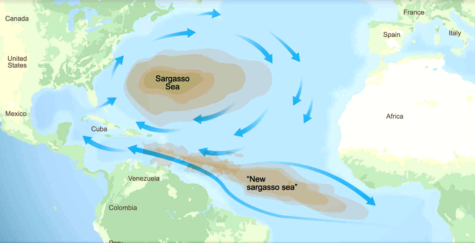
SARGASSUM - The giant brown seaweed, having shown that it can spread from North to South Atlantic oceans, could spread to the Indian and Pacific oceans as a potentially invasive species. The proof of which (as a theory) is satellite pictures, and changing wind states. The spread witnessed here, could just as easily migrate between oceans, and thence to the bays and seas within those oceans.


We are concerned that with the oceans warming at a faster rate than predicted, and with the spill over of sargassum from the previously contained Sargasso Sea in the North Atlantic, to create an Atlantic Equatorial sargassum gyre, that it is almost inevitable, and we might expect to see a South Atlantic sargassum gyre in the not too distant future. The notion is that from that point on, with the Indian and Pacific oceans also warming at the same rate [if that is a factor], spillage around the Cape of Good Hope and eventually, Cape Horn, could become a distinct possibility, bypassing the Australian Capes (Leeuwin and Howe), with an Indonesian belt, since the Southern Ocean is probably inhospitable to sargassum.


COMPUTER SIMULATIONS & MECHANICAL CONTAINMENT DEVICES


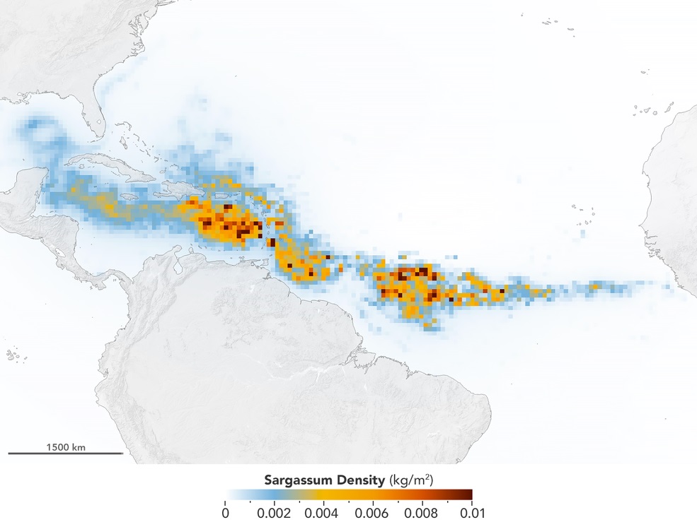
That all depends on temperature rise of seawater, combined with nutrient supply, and circulating currents, including winds. All of which is measurable, for variable algorithmic computer simulations. As has been performed on the influx to the Caribbean Sea, via the equatorial Atlantic gyre, by scientists at the University of South Florida in St. Petersburg's College of Marine Science, who used NASA satellite observations to discover and document the largest bloom of macroalgae. Others used Global Hybrid Coordinate Ocean Model surface currents (HYCOM) (Chassignet et al., 2007) and National Centers for Environmental Prediction Reanalysis (NCEP), in their simulations.


But nobody has yet created a computer model of a SeaVax Calypso or Sargasso, kind of ocean harvester, to determine if such a concept could control volume escalation, before they grow to be profusely irrepressible. Indeed such simulations may help develop such concepts in terms of capacity and operations, that they might actually contain the crisis, preventing a future worldwide state of emergency. Where, prevention is better than cure.


Since, this is a manmade phenomenon.


ABSTRACT - SIMULATING TRANSPORT PATHWAYS OF PELAGICC SARGASSUM FROM THE EQUATORIAL ATLANTIC INTO THE CARIBBEAN SEA 2018

Since 2011, beach inundation of massive amounts of pelagic Sargassum algae has occurred around the Caribbean nations and islands. Previous studies have applied satellite ocean color to determine the origins of this phenomenon. These techniques, combined with complementary approaches, suggest that, rather than blooms originating in the Caribbean, they arrive from the Equatorial Atlantic. However, oceanographic context for these occurrences remains limited.


Here, we present results from synthetic particle tracking experiments that characterize the interannual and seasonal dynamics of ocean currents and winds likely to influence the transport of Sargassum from the Equatorial Atlantic into the Caribbean Sea. Our findings suggest that Sargassum present in the western Equatorial Atlantic (west of longitude 50°W) has a high probability of entering the Caribbean Sea within a year’s time. Transport routes include the Guiana Current, North Brazil Current Rings, and the North Equatorial Current north of the North Brazil Current Retroflection. The amount of Sargassum following each route varies seasonally.


This has important implications for the amount of time it takes Sargassum to reach the Caribbean Sea. By weighting particle transport predictions with Sargassum concentrations at release sites in the western Equatorial Atlantic, our simulations explain close to 90% of the annual variation in observed Sargassum abundance entering the Caribbean Sea. Additionally, results from our numerical experiments are in good agreement with observations of variability in the timing of Sargassum movement from the Equatorial Atlantic to the Caribbean, and observations of the spatial extent of Sargassum occurrence throughout the Caribbean. However, this work also highlights some areas of uncertainty that should be examined, in particular the effect of “windage” and other surface transport processes on the movement of Sargassum.


Our results provide a useful launching point to predict Sargassum beaching events along the Caribbean islands well in advance of their occurrence and, more generally, to understand the movement ecology of a floating ecosystem that is essential habitat to numerous marine species.


AUTHORS: Nathan F. Putman Gustavo J. Goni Lewis J. Gramer Chuanmin Hu Elizabeth M. Johns Joaquin Trinanes Mengqiu Wang


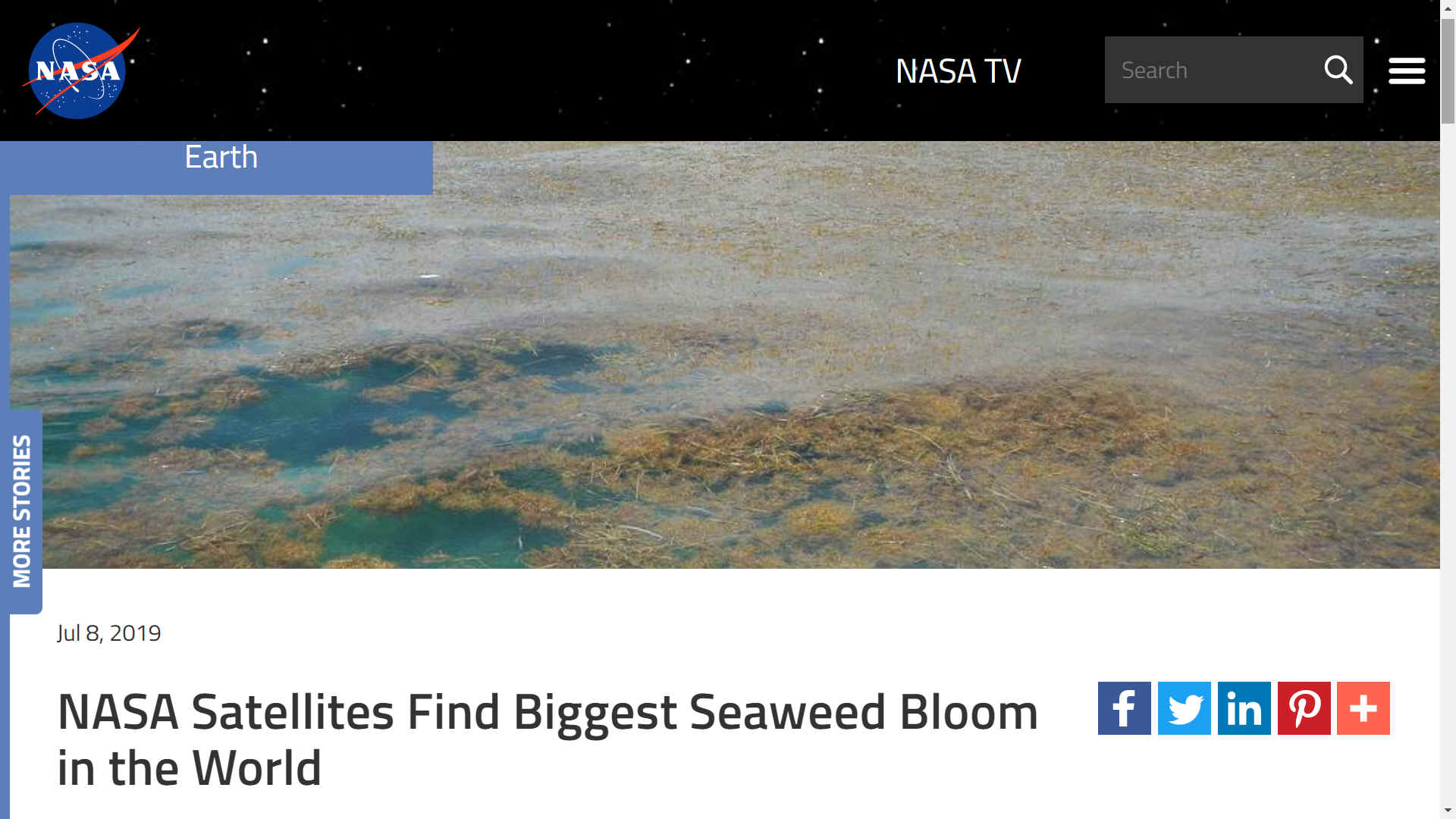
NASA SATELLITES FIND BIGGEST SEAWEED BLOOM IN THE WORLD 8 JULY 2019

An unprecedented belt of brown algae stretches from West Africa to the Gulf of Mexico—and it’s likely here to stay. Scientists at the University of South Florida in St. Petersburg's College of Marine Science used NASA satellite observations to discover and document the largest bloom of macroalgae in the world, dubbed the Great Atlantic Sargassum Belt, as reported in Science.

Based on computer simulations, they confirmed that this belt of the brown macroalgae Sargassum forms its shape in response to ocean currents. It can grow so large that it blankets the surface of the tropical Atlantic Ocean from the west coast of Africa to the Gulf of Mexico. In 2018, more than 20 million tons of it – heavier than 200 fully loaded aircraft carriers – floated in surface waters and became a problem to shorelines lining the tropical Atlantic, Caribbean Sea, Gulf of Mexico, and east coast of Florida, as it carpeted popular beach destinations and crowded coastal waters. [24M tons in 2022]

“The scale of these blooms is truly enormous, making global satellite imagery a good tool for detecting and tracking their dynamics through time,” said Woody Turner, manager of the Ecological Forecasting Program at NASA Headquarters in Washington.

Chuanmin Hu of the USF College of Marine Science, who led the study, has studied Sargassum using satellites since 2006. Hu spearheaded the work with first author Dr. Mengqiu Wang, a postdoctoral scholar in his Optical Oceanography Lab at USF. The team included others from USF, Florida Atlantic University, and Georgia Institute of Technology. The data they analyzed from NASA’s Moderate Resolution Imaging Spectroradiometer (MODIS) between 2000-2018 indicates a possible regime shift in Sargassum blooms since 2011.

In the satellite imagery, major blooms occurred in every year between 2011 and 2018 except 2013. This information, coupled with field measurements, suggests that no bloom occurred in 2013 because the seed populations of Sargassum measured during winter of 2012 were unusually low, Wang said.

Before 2011, most of the free floating Sargassum in the ocean was primarily found in patches around the Gulf of Mexico and Sargasso Sea. The Sargasso Sea is located on the western edge of the central Atlantic Ocean and named after its popular algal resident. In patchy doses in the open ocean, Sargassum contributes to ocean health by providing habitat for turtles, crabs, fish, and birds and, like other plants, producing oxygen via photosynthesis. But too much of this seaweed can crowd out marine species, especially near the coast.

In 2011, Sargassum populations started to explode in places it hadn’t been before, like the central Atlantic Ocean, and then it arrived in gargantuan gobs that suffocated shorelines and introduced a new nuisance for local environments and economies.

“The ocean’s chemistry must have changed in order for the blooms to get so out of hand,” Hu said. Sargassum reproduces from fragments of the parent plant, and it probably has several initiation zones around the Atlantic Ocean. It grows faster when nutrient conditions are favorable, and when its internal clock ticks in favor of reproduction.

The team identified key factors that are critical to bloom formation: a large seed population in the winter left over from a previous bloom, nutrient input from West Africa upwelling in winter, and nutrient input in the spring or summer from the Amazon River. Such discharged nutrients may have increased in recent years due to increased deforestation and fertilizer use, though Hu noted that the evidence for nutrient enrichment is preliminary and based on limited available data, and the team needs more research to confirm this hypothesis. In addition, Sargassum only grows well when salinity is normal and surface temperatures are normal or cooler. [but still seems to favor an equatorial bloom]

“Earth’s ocean biogeochemistry is changing in response to natural and human forcings. The Great Atlantic Sargassum Belt suggests that we may be witnessing ecosystem shifts in our ocean that could have important implications for marine organisms and ecosystem services, which humans depend on,” said Dr. Paula Bontempi, who manages NASA’s Ocean Biology and Biogeochemistry Program and serves as acting deputy director of NASA’s Earth Science Division at NASA Headquarters.

"This is all ultimately related to climate change, as climate affects precipitation and ocean circulation and even human activities [that can lead to Sargassum blooms], but what we’ve shown is that these blooms do not occur because of increased water temperature,” Hu said. “They are probably here to stay.”

This work was funded by several programs in NASA’s Earth Science Division, NOAA RESTORE Science Program, the JPSS/NOAA Cal/Val project, the National Science Foundation, and by a William and Elsie Knight Endowed Fellowship.

By: Ellen Gray (NASA's Earth Science News Team) Editor: Sara Blumberg


LIKELY STUDY AREAS:


Arabian Sea

Atlantic - North & South Equatorial

Banda Ceram Molucca & Timor Seas

Bay of Bengal

Celebes Sea

Gulf of Guinea

Gulf of Thailand

Indian Ocean

Java Sea

Pacific Ocean - North & South, Equatorial Belt (Costa Rica, Ecuador, Panama regions)

Philippine Sea

South China Sea


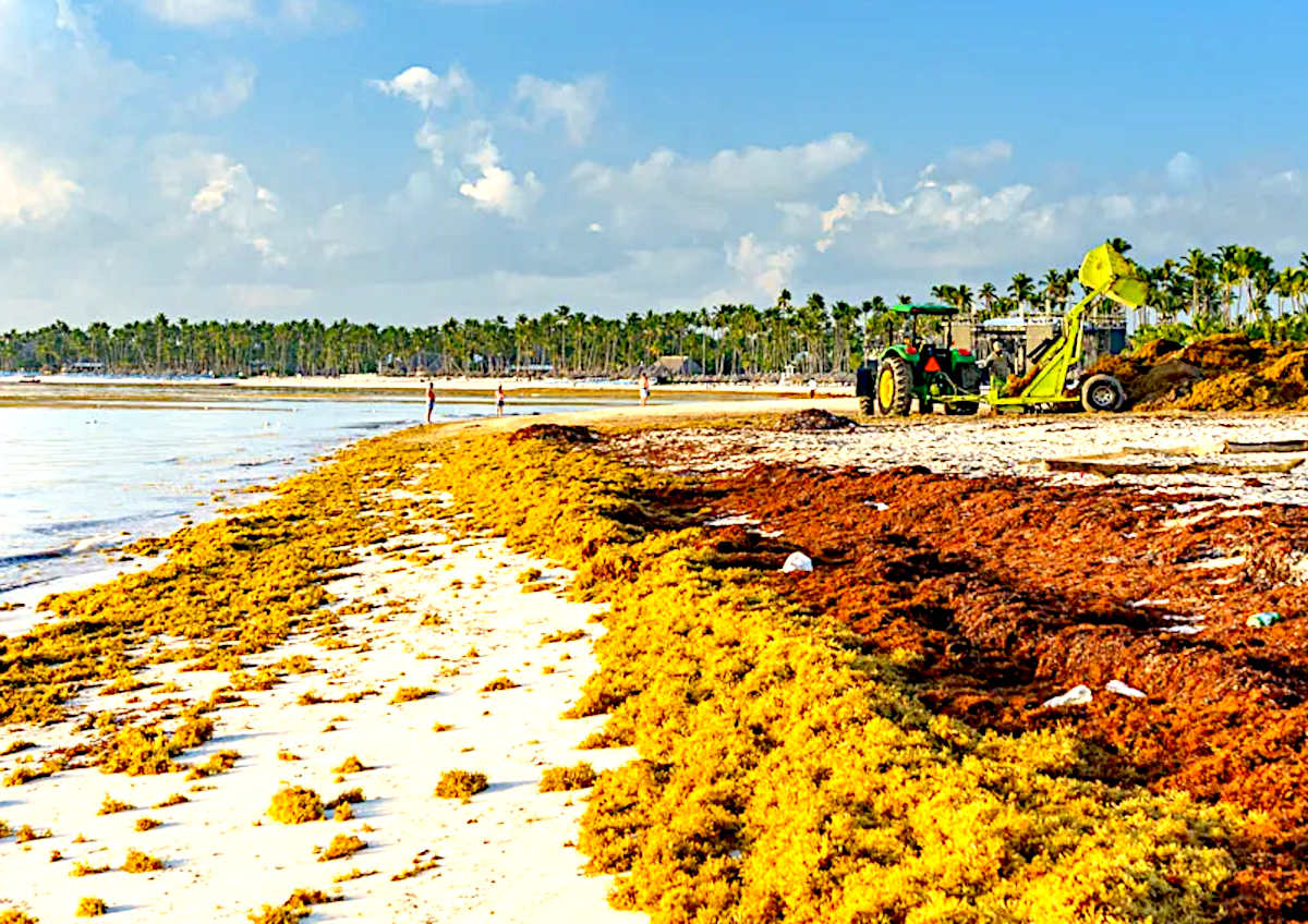
Seas and oceans in these latitudes could become inundated with sargassum (macro algae) if the rafts of floating seaweed manage to navigate less hospitable barriers, such as colder regions. Which at the moment, Cape Horn and the Cape of Good Hope appear to be barriers to invasion.


Honduras, Caribean island with a tide of plastic, pictures by Caroline Power    


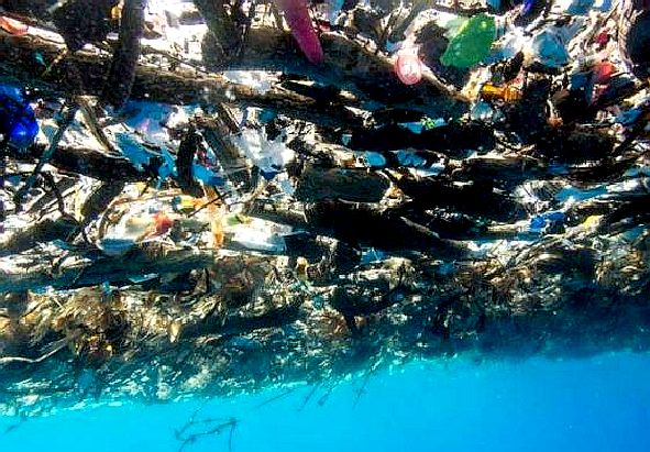
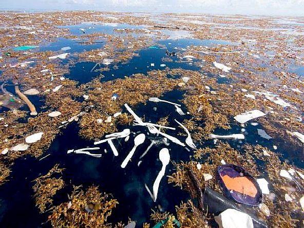
PLASTIC TIDE - These amazing pictures of a giant plastic tide were taken by Caroline Power. Please note how plastic and sargassum intertwine, creating a separation problem.


LINKS & REFERENCE


https://gmd.copernicus.org/articles/14/4069/2021/gmd-14-4069-2021.html

https://www.nasa.gov/feature/goddard/2019/nasa-satellites-find-biggest-seaweed-bloom-in-the-world

https://gmd.copernicus.org/articles/14/4069/2021/gmd-14-4069-2021.html

https://www.nasa.gov/feature/goddard/2019/nasa-satellites-find-biggest-seaweed-bloom-in-the-world


...


 This website is provided on a free basis as a public information service. copyright © Cleaner Oceans Foundation Ltd (COFL) (Company No: 4674774) August 2022. Solar Studios, BN271RF, United Kingdom. COFL is a charity without share capital. The names AmphimaxRiverVax™ and SeaVax™ are trademarks.


SATELLITE OBSERVATIONS: WORLD PLAGUES GIANT SARGASSUM SEAWEED MIGRATIONS TO ALL OCEANS