|
INDIAN
OCEAN
- NEW SARGASSO SEAS
Please use our
A-Z to
navigate this site or return HOME
SARGASSUM
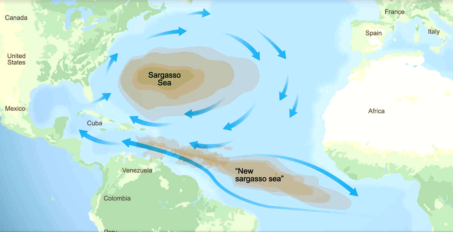
- The giant brown seaweed, having shown that it can spread
from North to South Atlantic oceans, could spread to the
Indian and Pacific oceans as a potentially invasive species.
The proof of which (as a theory) is satellite pictures, and
changing wind states. The spread witnessed here, could just as
easily migrate between oceans, and thence to the bays and seas
within those oceans.
We
are concerned that with the oceans warming at a faster rate
than predicted, and with the spill over of sargassum from the
Sargasso Sea in the North
Atlantic, to create an Atlantic
Equatorial
sargassum gyre, that it is almost inevitable, and we might
expect to see a South Atlantic sargassum gyre in the not too
distant future, in proportion to insolation, since
photosynthesis is the propagator of plant life.
If
that comes to pass, and with the Indian and
Pacific
oceans
also warming at the same rate as the Atlantic, so generating
faster currents and winds; spillage around
the horns could become a distinct possibility. In which case,
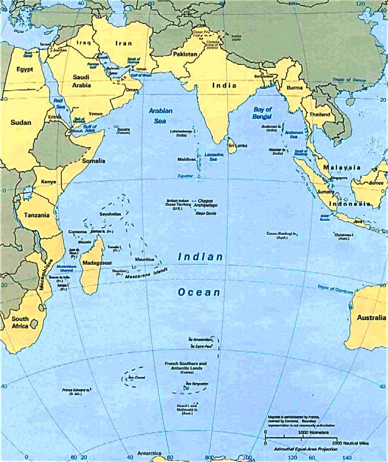
the Bay of Bengal would be a prime contender for a
micro sargassum gyre.
Dependent on location current circulation conditions. Or at
least may suffer a similar fate to the Caribbean Sea, where
the islands/shores therein suffer beaches strewn with mounds of sargassum, to
ruin fishing, tourism
and marine ecology.
ABOUT
THE
INDIAN OCEAN
The
Indian Ocean is the third-largest of the world's five oceanic divisions, covering 70,560,000 km2 (27,240,000 sq mi) or ~19.8% of the water on Earth's surface. It is bounded by Asia to the north, Africa to the west and Australia to the east. To the south it is bounded by the
Southern Ocean or Antarctica, depending on the definition in use. Along its core, the Indian Ocean has some large marginal or regional seas such as the
Arabian
Sea, Laccadive Sea, Somali Sea, Bay of
Bengal, and Andaman Sea.
MONSOONS - WARMEST OCEAN
The Indian Ocean is the warmest ocean in the world. Long-term ocean temperature records show a rapid, continuous warming in the Indian Ocean, at about 1.2 °C (34.2 °F) (compared to 0.7 °C (33.3 °F) for the warm pool region) during 1901–2012. Research indicates that human induced greenhouse warming, and changes in the frequency and magnitude of El Niño (or the Indian Ocean Dipole), events are a trigger to this strong warming in the Indian Ocean.
South of the Equator (20-5°S), the Indian Ocean is gaining heat from June to October, during the austral winter, while it is losing heat from November to March, during the austral summer.
In 1999, the Indian Ocean Experiment showed that fossil fuel and biomass burning in South and Southeast Asia caused
air pollution (also known as the Asian brown cloud) that reach as far as the Intertropical Convergence Zone at 60°S. This pollution has implications on both a local and global scale.
Several features make the Indian Ocean unique. It constitutes the core of the large-scale Tropical Warm Pool which, when interacting with the atmosphere, affects the climate both regionally and globally. Asia blocks heat export and prevents the ventilation of the Indian Ocean thermocline. That continent also drives the Indian Ocean monsoon, the strongest on Earth, which causes large-scale seasonal variations in ocean currents, including the reversal of the Somali Current and Indian Monsoon Current. Because of the Indian Ocean Walker circulation there are no continuous equatorial easterlies. Upwelling occurs near the
Horn of Africa and the Arabian Peninsula in the Northern Hemisphere and north of the trade winds in the Southern Hemisphere. The Indonesian Throughflow is a unique Equatorial connection to the Pacific.
The climate north of the equator is affected by a monsoon climate. Strong north-east winds blow from October until April; from May until October south and west winds prevail. In the Arabian Sea, the violent Monsoon brings rain to the Indian subcontinent. In the southern hemisphere, the winds are generally milder, but summer storms near Mauritius can be severe. When the monsoon winds change, cyclones sometimes strike the shores of the Arabian Sea and the Bay of Bengal. Some 80% of the total annual rainfall in India occurs during summer and the region is so dependent on this rainfall that many civilisations perished when the Monsoon failed in the past. The huge variability in the Indian Summer Monsoon has also occurred pre-historically, with a strong, wet phase 33,500–32,500 BP; a weak, dry phase 26,000–23,500 BC; and a very weak phase 17,000–15,000 BP, corresponding to a series of dramatic global events: Bølling-Allerød, Heinrich, and Younger
Dryas.
ABSTRACT:
SARGASSUM (FUCALES, PHAEPHYCEAE) IN MAURITIUS AND RÉUNION, WESTERN INDIAN OCEAN
Mattio L., Zubia M., Loveday B, Crochelet E., Duong N., Payri C.E., Bhagooli R. and Bolton J.J. 2013. Taxonomic revision and biogeography using hydrodynamic dispersal models. Phycologia 52: 578–594. DOI: 10.2216/13-150.1
Mauritius and Réunion are part of the Mascarene Islands situated in the southwestern Indian Ocean, c. 800 km east of Madagascar. A total of 44 different Sargassum species and subspecific taxa was listed in the literature for these islands. This was a remarkable number for such isolated and small islands, and was more than have been recorded from Madagascar or other East African countries. The first aim of our study was to revise these species lists using newly collected specimens to provide a reliable and illustrated tool for the identification of the Mauritian and Réunion Sargassum.
On the basis of morphological and molecular analyses, a total of six taxa was identified as S. cymosum f. borbonicum, S. obovatum, S. pfeifferae (reinstated), S. polycystum, S. portierianum and S. robillardii (stat. nov.). A seventh taxon, S. scopula, was identified from a herbarium collection but not re-collected. As a result of our taxonomic revision, we concluded that most of the species listed in the literature for both Mauritius and Réunion were misidentifications or synonyms, and we proposed three new taxonomic synonyms. The biogeography of the six Sargassum taxa was further investigated using local and regional hydrodynamic dispersal models.
Results underlined the isolated position of the Mascarene Islands with (1) unlikely import of Sargassum in present-day conditions, (2) likely dispersal/exchanges within the archipelago and (3) a two-pronged export of Sargassum to the east coast of Madagascar and the Seychelles with a major stream northwestward and a weaker stream southwestward. These oceanic conditions had probably shaped the Sargassum diversity of the Mascarene Islands and in particular explained the endemicity of S. cymosum f. borbonicum and restricted distribution of S. obovatum, S. pfeifferae, S. robillardii and S. scopula.
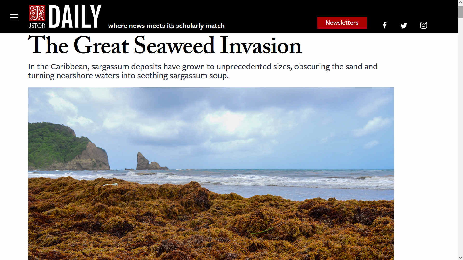
SARGASSUM: JSTOR DAILY 24 OCTOBER 2018 - THE GREAT SEAWEED INVASION
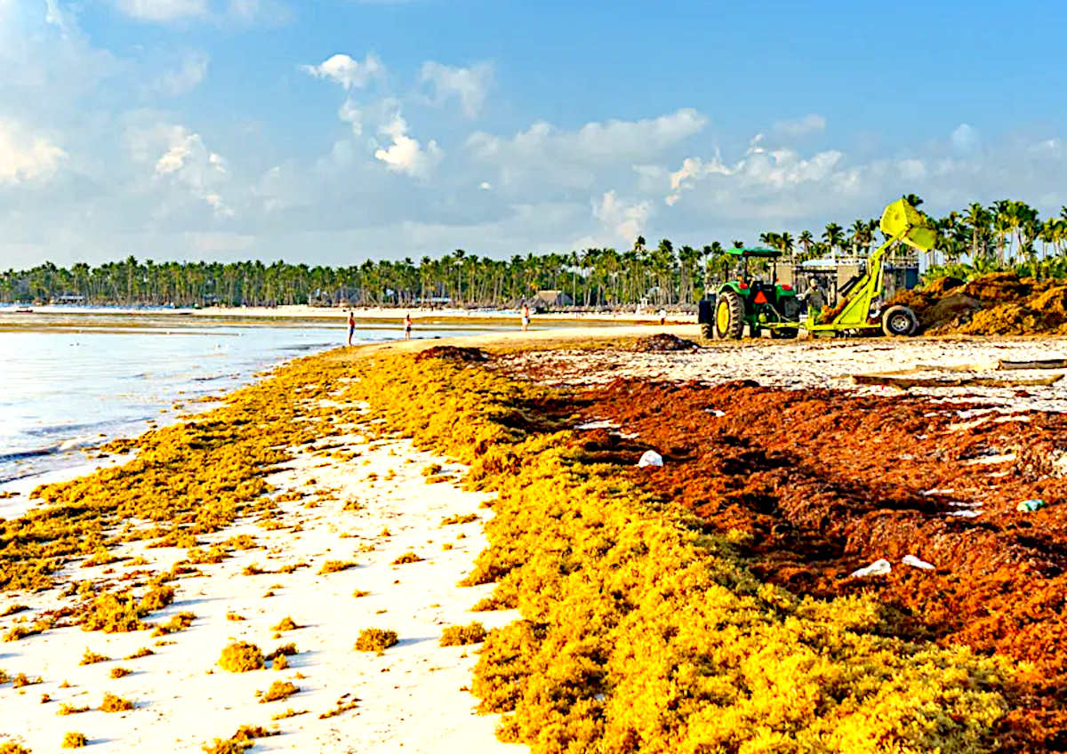
In the Caribbean, sargassum deposits have grown to unprecedented sizes, obscuring the sand and turning nearshore waters into seething sargassum soup.
They’d seen seaweed before, but nothing like this.
From the shores of Nigeria, to remote villages in the West Indies, to the tourist beaches of
Quintana Roo and the glossy high rises of Florida, the seaweed kept coming. Each incoming tide added to the precarious cliffs of algae until they were taller than grown men. The piles reeked of decay, disgorging dead fish and smothered turtles. Tourists stayed away. Out in the harbors, boats floated, useless, on dense tides of solid brown weeds. In the past, villagers might have harvested the beached seaweed to dry or bury as fertilizer, but the sheer volume of it on the
shoreline - trapped and rotting - made any practical use impossible. They could only watch as the piles grew higher. The year was 2011, and something was wrong.
An attempt to find a solution to this ecological mystery has been underway for the better part of the past decade, a search that has stretched from the Sahara Desert to the
Amazon
rainforest, from the Bermuda triangle to outer space. More importantly, it would serve as a reminder of how little we know about what’s happening in the oceans that occupy the majority of our planet
- and of how rapidly our own actions might be changing them beyond recognition.
If you’ve ever been out on a boat, you’ve probably seen pelagic sargassum. It floats on the ocean’s surface in narrow, shifting bands, driven by the competing forces of wind and water. From above, sun-baked sargassum rafts look like barren, discolored ribbons of oceanic detritus. From below, they are as complex and teeming with life as inverted
coral
reefs. Green-brown fronds trail spherical air sacs; coin-sized
sea turtles and fish whose patterns imitate sun on water dart in and out of the algal forest. In tropical waters, where nutrients are scarce and marine life scattered, a sargassum raft is an oasis of life and productivity. Floating sargassum acts as a mobile buffet, supporting entire food chains, from primary producers to top predators.
Looking closer at a sargassum mat, you might notice two different plants: needle-leaved Sargassum natans, which forms the majority of pelagic sargassum biomass, and broad-leaved, bushy Sargassum fluitans, which makes up the rest. Although the sargassum family includes hundreds of other members, most are sedentary plants tethered to the seafloor. These two species, found only in the
Atlantic (at the moment), are the only fully pelagic (open sea) members of their genus.
For a long time, the origins of floating sargassum remained a mystery. Were the plants that formed them completely free-living? Or had they once been rooted before becoming detached by waves or storms? The confusion stemmed from the fact that nobody had ever found reproductive organs on either of the two floating sargassum species. Eventually, observers concluded that pelagic sargassum really do reproduce at sea. When enough nutrients are available, the plants undergo rapid growth and, in a process called vegetative fragmentation, break into smaller pieces. These independent offshoots eventually form mature plants, and the cycle begins again.
IT'S NO COINCIDENCE THAT THE LOCATION OF THE SARGASSO SEA MATCHES THAT OF THE BERMUDA TRIANGLE
Adding further to the mystery, until fairly recently, observers could only guess at where sargassum mats came from. In a 1914 speech to the American Philosophical Society, naturalist William Farlow summed up a few of the more colorful speculations: “Von Marten’s theory that the gulf-weed originated in the Indian Ocean and was carried by currents round the
Cape of Good Hope to the Sargasso Sea has nothing to support it, nor can the theory of Ed. Forbes that the floating gulf-weed is the survival of Sargassum growing on the submerged
Atlantis be seriously considered.”
Thanks to remote sensing, we now have a more accurate idea of where sargassum originates (unfortunately, not Atlantis). Although small blooms of sargassum occur throughout the tropics, most sargassum production is concentrated in a few hotspots, particularly the northwestern Gulf of Mexico, where sargassum plants grow and fragment each spring during periods of high nutrient availability. Their offshoots catch a ride on powerful loop currents to the Gulf Stream, which eventually brings them to the Sargasso Sea, east of the Bahamas. The Sargasso Sea, considered the world’s only sea with no terrestrial boundaries, is enormous, borderless, and bright blue. It is ringed by competing oceanic currents that convey passive oceanic drifters
- hatchling sea turtles, larvae from fish and eels,
trash - into a sort of watery holding cell. Those that can leave under their own steam eventually do, once they grow large enough; those that can’t either spin off on fortuitous ocean currents or float around in a permanent raft of flotsam until they decompose. While the Sargasso Sea likely doesn’t produce much new sargassum
- nutrients there are too scarce to support large-scale growth and
fragmentation - it’s very good at collecting it.
It’s no coincidence that the location of the Sargasso Sea matches that of the Bermuda Triangle, a mysterious stretch of ocean where things are known to vanish, never to be seen again. Sailors from Columbus onward reported sargassum mats thick enough to impede
navigation - or even disable ships. Writing for the royal geographical Society in 1925, Captain C.C. Dixon asked:
Who could know whether this weed got thicker and thicker till there was no turning back? Its changing tints and shadows as daylight faded and at the approach of dawn needed but little help from the imagination to be wrought into fearsome monsters that inhabited its depth and whose very appearance would steal away one’s sanity.
Mariners imaginatively conjured a gyre of ghost ships from every era of navigation, tangled in sargassum and doomed to turn in endless circles until they disintegrated or sank. In modern times, the Sargasso Sea is described, perhaps more realistically, as containing a large amount of seagrass diluted over a vast region, only occasionally forming the epic mats described in early narratives (never thick enough to actually trap a ship).
Until recently, sargassum patterns were relatively easy to predict. From their Sargasso Sea stronghold, modest quantities might shoot off into the Gulf Stream, catch lateral currents, or ride storm surges that convey them to tropical beaches on either side of the Atlantic. However, in 2011, that pattern abruptly changed. In the Caribbean, sargassum deposits grew to several meters thick, obscuring the sand and turning nearshore waters into seething sargassum soup. Along the shores of West Africa, similarly unprecedented levels of sargassum choked the ocean beaches.
Although news coverage of the sargassum bloom tended to focus on lost revenue from tourism, excess sargassum is more than just an aesthetic concern. At sea, sargassum is buoyant and full of life; landlocked, it’s heavy and putrid. While small amounts of beached sargassum can create refuges for invertebrates and provide foraging areas for shorebirds, large quantities quickly become unusable and dangerous. Deep deposits can bury hatchling sea turtles, who emerge from nests laid months earlier to find themselves beneath meters-deep vegetation. Decaying sargassum also releases
hydrogen
sulfide, a noxious gas that can be mildly toxic to humans.
The source of the sudden sargassum influx proved difficult to pinpoint. Initial theories ranged from the effects of dispersants used to sink oil during the 2010
Deepwater Horizon oil spill in the Mississippi Delta to unusually severe African dust storms that airlifted nutrients to the Atlantic.
Oddly enough, the eventual solution came from outer space. Images of ocean reflectivity from satellites proved able to distinguish floating sargassum mats, which appear as dark spots, from the surrounding water. By examining satellite imagery from that year, scientists noticed a new hotspot for sargassum production: an area off the northern coast of Brazil, at the outflow of the Amazon River, where in the past hardly any sargassum growth had been detected. The amount of sargassum produced in this new area dwarfed any previous estimates from outside the Sargasso Sea. Although sargassum production fluctuates between years, the assumption was always that the lack of nutrients in the offshore waters of the Sargasso Sea imposed a ceiling on the amount of sargassum that could grow at any given time. This new hotspot, disturbingly close to shore, next to a highly productive river mouth, isn’t limited by a lack of nutrients or blocked in by an oceanic gyre. You’d be hard-pressed to find a more ideal producer and exporter of sargassum.
BY ALL PREDICTIVE MEASURES, SARGASSUM BLOOMS ARE HERE TO STAY
Since 2011, the increase in sargassum production and distribution has persisted, with abnormal sargassum blooms in at least five of the last eight years. 2015 was a new record year, and 2018 is already on track to surpass it; peak deposits are expected in late summer and through the fall. The blooms reflect a combination of environmental conditions, but are particularly severe in years with above-average sea-surface temperatures and high levels of nutrients in the
Amazon
river. Nutrient levels in the Amazon basin are increasing, driven mainly by nitrogen and phosphorous from fertilizers used in areas of rainforest recently converted to farmland. Downstream, their fertilizing effects are equally powerful for marine vegetation, sargassum included.
Although it’s difficult to know exactly how sargassum blooms first took hold in the region, they aren’t likely to go away any time soon. The continuing conversion of Brazilian rainforests to
agriculture fuels a constant demand for fertilizer, of which Brazil is one of the highest consuming nations on
planet
earth. Between steadily rising sea-surface temperatures and ever-increasing nutrient loads, it seems almost certain that high sargassum productivity will persist or increase in the Amazon outflow, and could spread to similar regions of nearshore tropical ocean. By all predictive measures, sargassum blooms are here to stay.
So, what’s the solution? Mass harvesting of sargassum at sea is impractical, with negative consequences for the many marine species that use sargassum mats as refuges, nurseries, and foraging areas. Once the plants wash ashore, removing the massive piles becomes even more challenging
- and potentially damaging to sensitive beach habitat. Until now, measures to address the sargassum influx have been short-term and piecemeal. Mexico has hired thousands of people to manually rake the seaweed, deployed floating barriers to keep it from reaching beaches, and used hydraulic pumps to collect it on the open ocean. However, there are signs of developing interest in the potential uses of sargassum: in fertilizers, biofuels, sunscreens, or food products. Learning to live with sargassum will depend on finding a balance, for tourists and fishermen as well as for pipefish and sea turtles.
Meanwhile, much about sargassum remains a mystery. It may not grow on the lost city of Altantis, or harbor ancient galleons doomed to spend eternity floating in circles. Although American and European eels are known to breed in the Sargasso Sea, nobody has ever seen them spawn in the wild. Perhaps it’s time for a new sargassum mythology: not one of monsters or shipwrecks, but of the profound mystery and vulnerability of the ocean itself.
By: Juliet Lamb
JSTOR RESOURCES
JSTOR is a digital library for scholars, researchers, and students. JSTOR Daily readers can access the original research behind our articles for free on JSTOR.
Fauna Associated with Pelagic Sargassum in the Gulf Stream - By: Judith Shulman Weis
The American Midland Naturalist, Vol. 80, No. 2 (Oct., 1968), pp. 554-558.
The University of Notre Dame
FORAGING OVER SARGASSUM BY WESTERN NORTH ATLANTIC SEABIRDS - By: MARY L. MOSER
& DAVID S. LEE - The Wilson Journal of Ornithology, Vol. 124, No. 1 (March 2012), pp. 66-72
Wilson Ornithological Society
Seabird Patchiness in Tropical Oceanic Waters: The Influence of Sargassum "Reefs"
- By: J. Christopher Haney
The Auk, Vol. 103, No. 1 (Jan., 1986), pp. 141-151
American Ornithological Society
THE SARGASSO SEA - By: Frank S. Collins
Rhodora, Vol. 19, No. 221 (May, 1917), pp. 77-84
New England Botanical Club, Inc.
The Vegetation of the Sargasso Sea - By: William G. Farlow
Proceedings of the American Philosophical Society, Vol. 53, No. 215 (Aug. - Dec., 1914), pp. 257-262
https://www.jstor.org/stable/984076
Evidence of Passive Migration of Green Turtle Hatchlings in Sargassum
By: Archie Carr and Anne Barkau Meylan
Copeia, Vol. 1980, No. 2 (May 1, 1980), pp. 366-368
American Society of Ichthyologists and Herpetologists (ASIH)
Plastics on the Sargasso Sea Surface - By: Edward J. Carpenter and K. L. Smith, Jr.
Science, New Series, Vol. 175, No. 4027 (Mar. 17, 1972), pp. 1240-1241
American Association for the Advancement of Science
The Sargasso Sea - By: C. C. Dixon
The Geographical Journal, Vol. 66, No. 5 (Nov., 1925), pp. 434-442
The Royal Geographical Society (with the Institute of British Geographers)
Sargassum accumulation may spell trouble for nesting sea turtles
By: Andrew S Maurer, Emma De Neef and Seth Stapleton
Frontiers in Ecology and the Environment, Vol. 13, No. 7 (September 2015), pp. 394-395
Wiley on behalf of the Ecological Society of America
A Comparison of Nutrient-Limited Productivity in Sargassum natans from Neritic vs. Oceanic Waters of the Western North Atlantic Ocean
- By: Brian E. Lapointe
Limnology and Oceanography, Vol. 40, No. 3 (May, 1995), pp. 625-633
Nutrient-limited growth of the coral reef macroalga Sargassum baccularia and experimental growth enhancement by nutrient addition in continuous flow culture
- By: Britta Schaffelke and David W. Klumpp
Marine Ecology Progress Series, Vol. 164 (April 9 1998), pp. 199-211
Inter-Research Science Center
SARGASSUM
ORIGINS
The North Atlantic Sargasso
Sea is where sargassum originates and was contained for
hundreds of years, until climate change and intensive farming.
But should
the unthinkable happen, and the invasive species take hold in
the South Atlantic, from whence to spread it's biological
advantage,
one can imagine the dire consequences, perhaps mirroring that
now ruining the Caribbean
Sea. Make no mistake, the
consequences of climate
change and intensive, fertilizer
based farming, could
become a deadly world contagion, to make other epidemics seem insignificant,
in terms of potential human tragedy.
An
animal has a means to exhaust toxic waste, essential for a
healthy lifestyle. The oceans have nowhere to dump the
excrement we dump in it. They just get more polluted. Except
for sargassum piling onto the shores, telling us that we have
reached the limit.
So,
what are the chances of it happening? Could there be a Sargasso
Sea in the Indian Ocean, (including the Arabian Sea, Bay of
Bengal), or belt, where the present welcoming waters are
turned into a cesspit
of foul smelling rotten seaweeds, as they release hydrogen
sulphide gas to choke visitors to their shores.
BIODIVERSITY
Of Earth's 36 biodiversity hotspot nine (or 25%) are located on the margins of the Indian Ocean.
- Madagascar and the islands of the western Indian Ocean (Comoros, Réunion, Mauritius, Rodrigues, the Seychelles, and Socotra), includes 13,000 (11,600 endemic) species of plants; 313 (183) birds; reptiles 381 (367); 164 (97) freshwater fishes; 250 (249) amphibians; and 200 (192) mammals.
The origin of this diversity is debated; the break-up of Gondwana can explain vicariance older than 100 mya, but the diversity on the younger, smaller islands must have required a Cenozoic dispersal from the rims of the Indian Ocean to the islands. A "reverse colonisation", from islands to continents, apparently occurred more recently; the chameleons, for example, first diversified on Madagascar and then colonised Africa. Several species on the islands of the Indian Ocean are textbook cases of evolutionary processes; the dung beetles, day geckos, and lemurs are all examples of adaptive radiation.
Many bones (250 bones per square metre) of recently extinct vertebrates have been found in the Mare aux Songes swamp in Mauritius, including bones of the Dodo bird (Raphus cucullatus) and Cylindraspis giant tortoise. An analysis of these remains suggests a process of aridification began in the southwest Indian Ocean
around 4,000 years ago.
- Maputaland-Pondoland-Albany (MPA); 8,100 (1,900 endemic) species of plants; 541 (0) birds; 205 (36) reptiles; 73 (20) freshwater fishes; 73 (11) amphibians; and 197 (3) mammals.
Mammalian megafauna once widespread in the MPA was driven to near extinction in the early 20th century. Some species have been successfully recovered since then — the population of white rhinoceros (Ceratotherium simum simum) increased from less than 20 individuals in 1895 to more than 17,000 as of 2013. Other species are still dependent of fenced areas and management programs, including black rhinoceros (Diceros bicornis minor), African wild dog (Lycaon pictus), cheetah (Acynonix jubatus), elephant (Loxodonta africana), and lion (Panthera leo).
- Coastal forests of eastern Africa; 4,000 (1,750 endemic) species of plants; 636 (12) birds; 250 (54) reptiles; 219 (32) freshwater fishes; 95 (10) amphibians; and 236 (7) mammals.
This biodiversity hotspot (and namesake ecoregion and "Endemic Bird Area") is a patchwork of small forested areas, often with a unique assemblage of species within each, located within 200 km (120 mi) from the coast and covering a total area of c. 6,200 km2 (2,400 sq mi). It also encompasses coastal islands, including Zanzibar and Pemba, and Mafia.
Horn of Africa; 5,000 (2,750 endemic) species of plants; 704 (25) birds; 284 (93)
reptiles; 100 (10) freshwater fishes; 30 (6) amphibians; and 189 (18) mammals.
- Coral reefs of the Maldives
This area, one of the only two hotspots that are entirely arid, includes the Ethiopian Highlands, the East African Rift valley, the Socotra islands, as well as some small islands in the Red Sea and areas on the southern Arabic Peninsula. Endemic and threatened mammals include the dibatag (Ammodorcas clarkei) and Speke's gazelle (Gazella spekei); the Somali wild ass (Equus africanus somaliensis) and hamadryas baboon
(Papio hamadryas).
It also contains many reptiles. In Somalia, the centre of the 1,500,000 km2 (580,000 sq mi) hotspot, the landscape is dominated by Acacia-Commiphora deciduous bushland, but also includes the Yeheb nut (Cordeauxia edulus) and species discovered more recently such as the Somali cyclamen (Cyclamen somalense), the only cyclamen outside the Mediterranean. Warsangli linnet (Carduelis johannis) is an endemic bird found only in northern Somalia. An unstable political situation and mismanagement has resulted in overgrazing which has produced one of the most degraded hotspots where only c. 5 % of the original habitat remains.
- The Western Ghats–Sri Lanka; 5,916 (3,049 endemic) species of plants; 457 (35) birds; 265 (176) reptiles; 191 (139) freshwater fishes; 204 (156)
amphibians; and 143 (27) mammals.
Encompassing the west coast of India and Sri Lanka, until c. 10,000 years ago a landbridge connected Sri Lanka to the Indian Subcontinent, hence this region shares a common community of species.
- Indo-Burma; 13.500 (7,000 endemic) species of plants; 1,277 (73) birds; 518 (204) reptiles; 1,262 (553) freshwater fishes; 328 (193) amphibians; and 401 (100) mammals.
Indo-Burma encompasses a series of mountain ranges, five of Asia's largest river systems, and a wide range of habitats. The region has a long and complex geological history, and long periods rising sea levels and glaciations have isolated ecosystems and thus promoted a high degree of endemism and speciation. The region includes two centres of endemism: the Annamite Mountains and the northern highlands on the China-Vietnam border. Several distinct floristic regions, the Indian, Malesian, Sino-Himalayan, and Indochinese regions, meet in a unique way in Indo-Burma and the hotspot contains an estimated 15,000–25,000 species of vascular plants, many of them endemic.
- Sundaland; 25,000 (15,000 endemic) species of plants; 771 (146) birds; 449 (244) reptiles; 950 (350) freshwater fishes; 258 (210) amphibians; and 397 (219) mammals.
Sundaland encompasses 17,000 islands of which Borneo and Sumatra are the largest. Endangered mammals include the Bornean and Sumatran orangutans, the proboscis monkey, and the Javan and Sumatran rhinoceroses.
- Wallacea; 10,000 (1,500 endemic) species of plants; 650 (265) birds; 222 (99) reptiles; 250 (50) freshwater fishes; 49 (33) amphibians; and 244 (144) mammals.
Southwest Australia; 5,571 (2,948 endemic) species of plants; 285 (10) birds; 177 (27) reptiles; 20 (10) freshwater fishes; 32 (22) amphibians; and 55 (13) mammals.
Stretching from Shark Bay to Israelite Bay and isolated by the arid Nullarbor Plain, the southwestern corner of Australia is a floristic region with a stable climate in which one of the world's largest floral biodiversity and an 80% endemism has evolved. From June to September it is an explosion of colours and the Wildflower Festival in Perth in September attracts more than half a million visitors.
MARINE LIFE
Among the tropical oceans, the western Indian Ocean hosts one of the largest concentrations of phytoplankton blooms in summer, due to the strong monsoon winds. The monsoonal wind forcing leads to a strong coastal and open ocean upwelling, which introduces nutrients into the upper zones where sufficient light is available for photosynthesis and phytoplankton production. These
phytoplankton blooms support the marine ecosystem, as the base of the marine food web, and eventually the larger fish species. The Indian Ocean accounts for the second-largest share of the most economically valuable tuna catch. Its fish are of great and growing importance to the bordering countries for domestic consumption and export. Fishing fleets from
Russia,
Japan,
South
Korea, and Taiwan also exploit the Indian Ocean, mainly for shrimp and tuna.
Research indicates that increasing ocean temperatures are taking a toll on the marine ecosystem. A study on the phytoplankton changes in the Indian Ocean indicates a decline of up to 20% in the marine plankton in the Indian Ocean, during the past six decades. The tuna catch rates have also declined 50–90% during the past half-century, mostly due to increased industrial fisheries, with the ocean warming adding further stress to the fish species.
80% of the Indian Ocean is open ocean and includes nine large marine ecosystems: the Agulhas Current, Somali Coastal Current, Red Sea, Arabian Sea, Bay of Bengal, Gulf of Thailand, West Central Australian Shelf, Northwest Australian Shelf, and Southwest Australian Shelf. Coral reefs cover c. 200,000 km2 (77,000 sq mi). The coasts of the Indian Ocean includes beaches and intertidal zones covering 3,000 km2 (1,200 sq mi) and 246 larger estuaries. Upwelling areas are small but important. The hypersaline salterns in India covers between 5,000–10,000 km2 (1,900–3,900 sq mi) and species adapted for this environment, such as Artemia salina and Dunaliella salina, are important to bird life.
Coral reefs, sea grass beds, and mangrove forests are the most productive ecosystems of the Indian Ocean — coastal areas produce 20 tones per square kilometre of fish. These areas, however, are also being urbanised with populations often exceeding several thousand people per square kilometre and
fishing techniques become more effective and often destructive beyond sustainable levels while the increase in sea surface temperature spreads coral bleaching.
Mangroves covers 80,984 km2 (31,268 sq mi) in the Indian Ocean region, or almost half of the world's mangrove habitat, of which 42,500 km2 (16,400 sq mi) is located in Indonesia, or 50% of mangroves in the Indian Ocean. Mangroves originated in the Indian Ocean region and have adapted to a wide range of its habitats but it is also where it suffers its biggest loss of habitat.
In 2016 six new animal species were identified at hydrothermal vents in the Southwest Indian Ridge: a "Hoff" crab, a "giant peltospirid" snail, a whelk-like snail, a limpet, a scaleworm and a polychaete worm.
The West Indian Ocean coelacanth was discovered in the Indian Ocean off South Africa in the 1930s and in the late 1990s another species, the Indonesian coelacanth, was discovered off Sulawesi Island, Indonesia. Most extant coelacanths have been found in the Comoros. Although both species represent an order of lobe-finned fishes known from the Early Devonian (410 mya) and though extinct 66 mya, they are morphologically distinct from their Devonian ancestors. Over millions of years, coelacanths evolved to inhabit different environments — lungs adapted for shallow, brackish waters evolved into gills adapted for deep marine waters.
OCEANOGRAPHY
40% of the sediment of the Indian Ocean is found in the Indus and Ganges fans. The oceanic basins adjacent to the continental slopes mostly contain terrigenous sediments. The ocean south of the polar front (roughly 50° south latitude) is high in biologic productivity and dominated by non-stratified sediment composed mostly of siliceous oozes. Near the three major mid-ocean ridges the ocean floor is relatively young and therefore bare of sediment, except for the Southwest Indian Ridge due to its ultra-slow spreading rate.
The ocean's currents are mainly controlled by the monsoon. Two large gyres, one in the northern hemisphere flowing clockwise and one south of the equator moving anticlockwise (including the Agulhas Current and Agulhas Return Current), constitute the dominant flow pattern. During the winter monsoon (November–February), however, circulation is reversed north of 30°S and winds are weakened during winter and the transitional periods between the monsoons.
The Indian Ocean contains the largest submarine fans of the world, the Bengal Fan and Indus Fan, and the largest areas of slope terraces and rift valleys.
The inflow of deep water into the Indian Ocean is 11 Sv, most of which comes from the Circumpolar Deep Water (CDW). The CDW enters the Indian Ocean through the Crozet and Madagascar basins and crosses the Southwest Indian Ridge at 30°S. In the Mascarene Basin the CDW becomes a deep western boundary current before it is met by a re-circulated branch of itself, the North Indian Deep Water. This mixed water partly flows north into the Somali Basin whilst most of it flows clockwise in the Mascarene Basin where an oscillating flow is produced by Rossby waves.
Water circulation in the Indian Ocean is dominated by the Subtropical Anticyclonic Gyre, the eastern extension of which is blocked by the Southeast Indian Ridge and the 90°E Ridge. Madagascar and the Southwest Indian Ridge separate three cells south of Madagascar and off South Africa. North Atlantic Deep Water reaches into the Indian Ocean south of Africa at a depth of 2,000–3,000 m (6,600–9,800 ft) and flows north along the eastern continental slope of Africa. Deeper than NADW, Antarctic Bottom Water flows from Enderby Basin to Agulhas Basin across deep channels (<4,000 m (13,000 ft)) in the Southwest Indian Ridge, from where it continues into the Mozambique Channel and Prince Edward Fracture Zone.
North of 20° south latitude the minimum surface temperature is 22 °C (72 °F), exceeding 28 °C (82 °F) to the east. Southward of 40° south latitude, temperatures drop quickly.
The Bay of Bengal contributes more than half (2,950 km3 or 710 cu mi) of the runoff water to the Indian Ocean. Mainly in summer, this runoff flows into the Arabian Sea but also south across the Equator where it mixes with fresher seawater from the Indonesian Throughflow. This mixed freshwater joins the South Equatorial Current in the southern tropical Indian Ocean. Sea surface salinity is highest (more than 36 PSU) in the Arabian Sea because evaporation exceeds precipitation there. In the Southeast Arabian Sea salinity drops to less than 34 PSU. It is the lowest (c. 33 PSU) in the Bay of Bengal because of river runoff and precipitation. The Indonesian Throughflow and precipitation results in lower salinity (34 PSU) along the Sumatran west coast. Monsoonal variation results in eastward transportation of saltier water from the Arabian Sea to the Bay of Bengal from June to September and in westerly transport by the East India Coastal Current to the Arabian Sea from January to April.
An Indian Ocean garbage patch was discovered in 2010 covering at least 5 million square kilometres (1.9 million square miles). Riding the southern Indian Ocean Gyre, this vortex of plastic garbage constantly circulates the ocean from Australia to Africa, down the Mozambique Channel, and back to Australia in a period of six years, except for debris that gets indefinitely stuck in the centre of the gyre. The garbage patch in the Indian Ocean will, according to a 2012 study, decrease in size after several decades to vanish completely over centuries. Over several millennia, however, the global system of garbage patches will accumulate in the North Pacific.
There are two amphidromes of opposite rotation in the Indian Ocean, probably caused by Rossby wave propagation.
Icebergs drift as far north as 55° south latitude, similar to the Pacific but less than in the Atlantic where icebergs reach up to 45°S. The volume of iceberg loss in the Indian Ocean between 2004 and 2012 was 24 Gt.
Since the 1960s, anthropogenic warming of the global ocean combined with contributions of freshwater from retreating land ice causes a global rise in sea level. Sea level increases in the Indian Ocean too, except in the south tropical Indian Ocean where it decreases, a pattern most likely caused by rising levels of greenhouse gases.
COMPUTER
SIMULATIONS & CONTAINMENT DEVICES
That
all depends on temperature rise of seawater, combined with
nutrient supply, and circulating currents, including winds.
All of which is measurable, for variable algorithmic computer
simulations. As has been performed on the influx to the
Caribbean Sea, via the equatorial Atlantic gyre, by scientists at the
University of South Florida in St. Petersburg's College of Marine Science,
who used NASA satellite observations to discover and document the largest bloom of macroalgae.
Others used Global Hybrid Coordinate Ocean Model surface currents (HYCOM) (Chassignet et al., 2007) and National Centers for Environmental Prediction Reanalysis
(NCEP), in their simulations.
But
nobody has yet created a computer model of a SeaVax
Calypso or Sargasso,
used in various (fleet formations incorporating SeaNet) to determine if such a concept could control volume
escalation, before they grow to be profusely irrepressible.
Indeed such simulations may help develop such concepts in
terms of capacity and operations, that they may, or may not, contain the
crisis, preventing a worldwide state of emergency - by nipping
it in the bud.
THEORY
DEVELOPMENT
At
this stage of the formulation of his theory, the innovator is
considering the awful prospect, based on the demonstrable and
devastating spread of sargassum from the North Atlantic to the
Equatorial South Atlantic, but not yet migrating to the more
general south, due presumably, to temperatures not yet being to the
liking of the buoyant seaweed.
The
three major oceans are all interconnected via currents and
driving winds. The main barrier to migration at present, is
the temperature and level of nutrients, that is lower where
the seaweed
mats could pass from one to another. But that is by no means a
hard point, as the melting
of the polar caps indicates. We are living in changeable
times, where the unthinkable is taking place, as a pace faster
than previously supposed.
In
other words, the impossible is rapidly becoming possible. And
there is no containment system at present, to prevent that
from happening; no international coordination, or action plan.
A recipe for disaster you may think!
FACTUAL
BACKGROUND
The
sargassum crisis seen in the Caribbean Sea and
Gulf of Mexico could be just the
beginning of a worldwide plague, stemming from our inability
to curb political insatiability for fossil fuels - to power failing economic strategies, based on growth, when we
have already used up the planet twice over, in sustainable
terms.
The
answer to failed political policies is very often a jolly good war,
(Russia Vs Ukraine). When all cock-ups get thrown to the wind in
the media scrum, and a whitewash ensues, until the next band of
post-war cutthroats is elected, each with their hands in the
pockets of Lucifer's climate change deniers.
That said, it would take a nuclear conflict to reduce earth's population
significantly enough to brake global warming - but then the planet
would be barren and unable to support human life. Hence, an
unthinkable solution to all but the most desperate of
homicidal kleptocrats: warmongers.
But,
ignoring thermonuclear first strikes for now, even if we
transition to renewables
immediately, global warming
will not reverse for 30-50 years at best, and that is
with a fair political wind. Meaning that the conditions for sargassum
to populate welcoming equatorial waters (rich in nutrients) around the globe,
remains a distinct possibility. Such as the:
Arabian
Sea
Atlantic
- North &
South
Equatorial
Banda
Ceram Molucca & Timor Seas
Bay
of Bengal
Celebes
Sea
Gulf
of Guinea
Gulf
of Thailand
Indian
Ocean
Java
Sea
Pacific
Ocean - North & South, Equatorial
Belt (Costa Rica, Ecuador,
Panama regions)
Philippine
Sea
South
China Sea
Seas
and oceans in these latitudes could become inundated with macro
algae, if the rafts of floating seaweed
manage to navigate
less hospitable barriers, such as colder regions. Which at the
moment, Cape Horn and the Cape
of Good Hope appear to offer some protection from
invasion.
THESIS
This
is a theory proposed by Nelson
Kay (as a volunteer) in August of 2022, based on his work with the SeaVax
team from 2016 - 2020. Though that exertion was mostly concerning
micro and
macro plastic recovery and river
containment, the ocean engineering and logistical challenges
posed by SeaVax
are kindred concepts, and may be sympathetically adapted or
even interchangeable to some degree. And may one day inspire
others to devise a practical resolution.
Academics
and scientific institutions inclined to test such thesis, or
otherwise wishing to provide data or technological assistance,
positive or negative, should please contact
the Cleaner Ocean Foundation in the first instance. The
aim being to prove or disprove the concept, to advance our
knowledge in this little understood area of Oceanology/Oceanography.
Students at all levels are most welcome, as are degree level
students and post graduates looking to higher level
qualifications, or simply to gain experience.
There
are a million reasons for not doing something, and only one for
taking up a challenge. Most people will use
manifold negatives to sit back in their
armchairs, and postulate. But, every now and again, someone is foolhardy enough to
roll their sleeves up - and experiment - because they feel they
must. Despite the enormity of
the task. And that is how this website came about, in support
of the SeaVax
project in 2017.
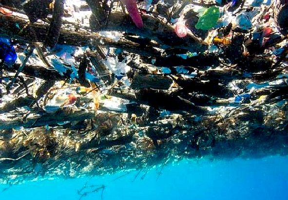
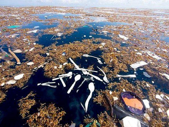
PLASTIC
TIDE - These amazing pictures of a giant plastic tide were
taken by Caroline Power. Please note how plastic and sargassum
intertwine, creating a separation problem.
CARIBBEAN
ISLANDS UNDER THREAT A-Z
Anguilla
Antigua
and Barbuda
Aruba
(Netherlands)
Bahamas
Barbados
British
Virgin Islands
Caribbean
Netherlands
Cayman
Islands (UK)
Cuba
Curaçao
(Netherlands)
Dominica
Dominican
Republic (Hispaniola)
Grenada
Guadeloupe
(France)
Haiti
(Hispaniola)
Jamaica
Martinique
(France)
Montserrat
Puerto
Rico (US)
Roatán
Saint
Barthélemy
Saint
Kitts and Nevis
Saint
Lucia
Saint
Martin
Saint
Vincent and the Grenadines
Sint
Maarten (Netherlands)
Tortuga
Trinidad
and Tobago
Turks
and Caicos Islands
United
States Virgin Islands
LINKS
& REFERENCE
https://www.tandfonline.com/doi/full/10.2216/13-150.1?scroll=top&needAccess=true
https://daily.jstor.org/great-seaweed-invasion/
https://daily.jstor.org/daily-author/juliet-lamb/
https://www.tandfonline.com/doi/full/10.2216/13-150.1?scroll=top&needAccess=true
https://daily.jstor.org/great-seaweed-invasion/
This
website is provided on a free basis as a public information
service. copyright © Cleaner
Oceans Foundation Ltd (COFL) (Company No: 4674774)
August 2022. Solar
Studios, BN271RF, United Kingdom.
COFL
is a charity without share capital. The names Amphimax™
RiverVax™
SeaNet™
and SeaVax™
are trademarks.
|