|
SOUTH
CHINA
- SARGASSO SEA
Please use our
A-Z to
navigate this site or return HOME
SARGASSUM
- The giant brown seaweed, having shown that it can spread
from North to South Atlantic oceans, could spread to the
Indian and Pacific oceans as a potentially invasive species.
The proof of which (as a theory) is satellite pictures, and
changing wind states. The spread witnessed here, could just as
easily migrate between oceans, and thence to the bays and seas
within those oceans.
We
are concerned that with the oceans warming at a faster rate
than predicted, and with the spill over of sargassum from the
Sargasso Sea in the North
Atlantic, to create an Atlantic
Equatorial
sargassum gyre, that it is almost inevitable, and we might
expect to see a South Atlantic sargassum gyre in the not too
distant future, in proportion to insolation, since
photosynthesis is the propagator of plant life.
If
that comes to pass, and with the Indian and
Pacific
oceans
also warming at the same rate as the Atlantic, so generating
faster currents and winds; spillage around
the horns could become a distinct possibility. In which case,
the South China Sea could be a prime contender for a
micro sargassum gyre.
Dependent on location current circulation conditions. Or at
least may suffer a similar fate to the Caribbean Sea, where
the islands therein suffer beaches strewn with mounds of sargassum, to
ruin fishing, tourism
and marine ecology.
ABOUT
THE SOUTH
CHINA SEA
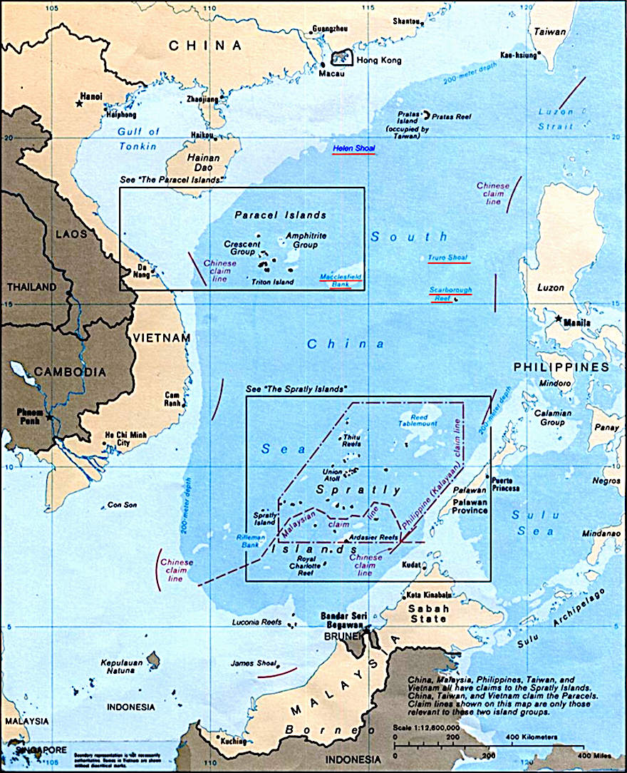
The South China Sea is a marginal sea of the Western Pacific Ocean. It is bounded in the north by the shores of South China (hence the name), in the west by the Indochinese Peninsula, in the east by the islands of Taiwan and northwestern Philippines (mainly Luzon, Mindoro and Palawan), and in the south by Borneo, eastern Sumatra and the Bangka Belitung Islands, encompassing an area of around 3,500,000 km2 (1,400,000 sq mi). It communicates with the East China Sea via the Taiwan Strait, the Philippine Sea via the Luzon Strait, the Sulu Sea via the straits around Palawan (e.g. the Mindoro and Balabac Strait), the Strait of Malacca via the Strait of Singapore, and the Java Sea via the Karimata and Bangka Strait.
The Gulf of Thailand and the Gulf of Tonkin are also part of the South China Sea. The shallow waters south of the Riau Islands are also known as the Natuna Sea.
The South China Sea is a region of tremendous economic and geostrategic importance. One-third of the world's maritime shipping passes through it, carrying over US$3 trillion in trade each year. Huge oil and natural gas reserves are believed to lie beneath its seabed. It also contains lucrative fisheries, which are crucial for the food security of millions in Southeast Asia.
The South China Sea Islands, collectively comprising several archipelago clusters of mostly small uninhabited islands, islets (cays and shoals), reefs/atolls and seamounts numbering in the hundreds, are subject to competing claims of sovereignty by several countries. These claims are also reflected in the variety of names used for the islands and the sea.
SOUTH CHINA SEA ISLANDS
The South China Sea Islands consist of over 250 islands, atolls, cays, shoals, reefs and seamounts in the South China Sea. The islands are mostly low and small, and have few inhabitants. The islands and surrounding seas are subject to overlapping territorial claims by the countries bordering the South China Sea.
The islands, shoals, and reefs are grouped into three archipelagos, plus the Zhongsha Islands (Macclesfield Bank and Scarborough Shoal). The South China Sea Islands as defined here consist of the sea's oceanic islands, and do not include the sea's continental shelf islands like Hainan and Natuna. Collectively, they have a total land surface area of less than 15 km2 at low tide.
The area is a political hot potato, with China claiming rights, as are other countries bordering the Islands.
TRADE ROUTE
The South China Sea is an extremely significant body of water in a geopolitical sense. The sea has historically been an important trade route between China, southeast Asia, and going to India and the west. A number of shipwrecks of trading ships that lie on the ocean's floor attest to a thriving trade going back centuries. Nine historic trade ships carrying ceramics dating back to the 10th century until the 19th century were excavated under Swedish engineer Sten Sjöstrand.
it is the second most used sea lane in the world, while in terms of world annual merchant fleet tonnage, over 50% passes through the Strait of Malacca, the Sunda Strait, and the Lombok Strait. Over 1.6 million m³ (10 million barrels) of crude oil a day are shipped through the Strait of Malacca, where there are regular reports of piracy, but much less frequently than before the mid-20th century.
NATURAL RESERVES
The region has proven oil reserves of around 1.2 km³ (7.7 billion barrels), with an estimate of 4.5 km³ (28 billion barrels) in total. Natural gas reserves are estimated to total around 7,500 km³ (266 trillion cubic feet). A 2013 report by the U.S. Energy Information Administration raised the total estimated oil reserves to 11 billion barrels. In 2014 China began to drill for
oil in waters disputed with Vietnam. The area in question is known as Vanguard Bank and which Vietnam officials claim lies within their country's 200-mile exclusive economic zone. China, however, disputes this fact.
According to studies made by the Department of Environment and Natural Resources, Philippines, this body of water holds one third of the entire world's marine biodiversity, thereby making it a very important area for the ecosystem. However the fish stocks in the area are depleted, and countries are using fishing bans as a means of asserting their sovereignty claims.
Indonesia's maritime waters have been breached by fishing fleets from Vietnam and the Philippines leading to said ships being seized and sunk by Indonesian authorities.
China announced in May 2017 a breakthrough for mining methane clathrates, when they extracted methane from hydrates in the South China Sea.
MARINE ALGAE OF SOUTH CHINA SEA -
2017 STUDY
The South China Sea (SCS) encompasses a tropical region stretching from Singapore in the southwest to the Strait of Taiwan in the northeast, across 22° of latitude bounded by
the coastlines of Malaysia, Thailand, Cambodia, Vietnam, China, the Philippines, Brunei and
Indonesia. On the west, the SCS is separated by a shallow sill from the Gulf of
Thailand. The sea surface area is about 3.6 million km2, with an average depth of over 1,200 m and a maximum depth of 5,000 m. The SCS contains 7.04% of the world’s coral
reefs and 0.93% of the world’s seamounts, with 0.31% of the sea surface being protected (Heileman, 2008).
The SCS is a highly productive (150–300 g C.m-2 yr-1) region based on global primary productivity estimates. It has a diverse range of habitats including mangroves, seagrass meadows,
coral reefs and soft bottom communities, representing the world’s most diverse shallow marine ecosystem (Morton & Blackmore, 2001). The 50 m depth contour largely follows the coast, with the widest shelves occurring along the eastern edge of the large marine ecosystem.
Rivers like the Pearl River in Guangdong,
China, Red River in northern Vietnam, and Mekong River in southern Vietnam, drain into the SCS, which also harbours islands like Hainan in the northwest, Pahlawan in the southeast as well as numerous small islands, atolls and reefs, including the Spratleys (Morton & Blackmore, 2001). The SCS is influenced by the Southwest Monsoon in the summer and the Northeast Monsoon in the Winter. The monsoonal winds and resulting currents greatly influence the distribution of coastal and marine species.
The countries at the rim of the SCS are amongst the most densely
populated in the world, where coastal and maritime communities depend greatly on marine resources for their
livelihoods. The SCS forms part of a megadiversity region in Southeast Asia that extends into the Coral Triangle, where seaweed farming contributes significantly to the enhancement of livelihoods of the coastal and maritime populations.
The Coral Triangle produces more than 70% of the global carrageenan (Phang et al., 2010).
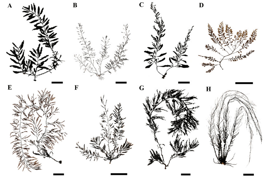
The marine algae in this paper refer to the marine macroalgae, commonly called the seaweeds. They are simplistically categorised into green seaweeds (Chlorophyta), brown
seaweeds (Ochrophyta) and red seaweeds (Rhodophyta).
The filamentous marine blue-green algae (Cyanophyta) are included in the list of marine algal flora of the SCS region, but the marine microalgae and
phytoplankton are excluded from the list.
Although the South China Sea (SCS) is one of the most productive marine ecoregions in the world, there is no report of marine algae covering this wide area. We here provide the first checklist of marine algae from the SCS, bordered by Indonesia, Malaysia, Philippines, Singapore, Thailand, and Vietnam. A total of 1,442 species including subspecies and varieties in 96 families were compiled in this checklist; 119 species in 12 families for Cyanophyta, 305 species in 22 families for Chlorophyta, 258 species in 14 families for Ochrophyta and 730 species in 48 families for Rhodophyta. Marine algal flora, compared using the Sorensen’s Similarity Index, is very similar between Malaysia, Singapore and Thailand. This preliminary checklist will provide a baseline for future taxonomic and biogeographical studies of marine algae in the region. Further international collaboration among phycologists will improve our knowledge of marine algae in the SCS.
This first checklist of the marine algae of South China Sea within the waters of the Philippines, Indonesia, Singapore, Malaysia, Thailand and Vietnam, may be considered a
baseline for future efforts in understanding the affinities and
bio-geographical distribution of the marine algal flora in the South China Sea and the Indo-West Pacific region. It is hoped that the flora of Taiwan and Southern China can be added in at a later stage. The documentation of the flora is important for conservation as well as management of the utilisation of this important resource which has potential for commercialization, especially in the production of new products like biopharmaceuticals and industrial materials.
8 authors, including: Siew-Moi Phang - University of Malaya; Hui Yin Yeong - University of Malaya;
Edna T. Ganzon-Fortes - University of the Philippines; Anchana Prathep - Prince of Songkla University
MOLECULAR ANALYSIS OF SARGASSUM FROM NORTHERN CHINA SEAS
2016
The species-level taxonomy of the marine brown algal genus Sargassum is problematic. To resolve some of these systematic issues in the northern China seas, a molecular analysis of Sargassum species was carried out using ITS-2, cox3, and rbcL
DNA
sequences.
Phylogenetic analyses confirmed eight species, including: S. confusum, S. fusiforme, S. hemiphyllum var. chinense, S. horneri, S. muticum, S. siliquastrum, S. thunbergii, and S. vachellianum. The previously described S. shandon-gense and S. qingdaoense, endemic to the Shandong Peninsula, are shown to be synonymous with S. vachellianum. Seven species previously described from the East China Sea were not observed, and require further investigation.
The main goal of this study was to re-examine the diversity of Sargassum along the Chinese coast in the Yellow Sea and East China Sea based on molecular analysis. Among 130 species previously recorded in China, we confirmed the presence of at least eight Sargassum species in the northern China seas, with seven belonging to the Sargassum subgen. Bactrophycus and one belonging to the Sargassum subgen. Sargassum. Our phylogenetic data indicated that none of the Sargassum species are endemic to the Yellow Sea and East China Sea, instead they are also in the South China Sea and adjacent seas.
Several previously recorded species in the East China Sea were not collected in the present study, possibly due to historical misidentification, seasonality of thallus occurrence, or scope of this work. We collected samples every month in some localities, but some previously recorded species were never present. For example, Sargassum horneri
has disappeared from the Nanji Islands, where a huge seaweed bed of S. horneri was well known for decades (Sun et al. 2008). In the same area, S. nigrifolioides Tseng et Lu had been described as a new species (Tseng & Lu 1985), but we failed to find it at the type locality. The frequent human activities in the area might be the major reason of
the dramatic reduction of biomass and diversity of Sargassum (Sun et al. 2009). The historical sampling localities have been destroyed or become reclaimed land, and the low light transparency in the seawater inhibits the growth of seaweeds.
About 130 Sargassum species were previously recorded in China, of which 49 were described as new species, however, most species have never been confirmed using molecular phylogenetics. Consequently, further studies on the diversity of Sargassum from the South China Sea and adjacent seas using DNA datasets are required. Ecological monitoring has also been proposed as a necessary approach to document the ontogenic and phenotypic variability at the intra and inter-population levels (Mattio & Payri 2011, Mattio et al. 2015). Integrative investigations using morphological, ecological, and molecular analyses are essential to resolve Sargassum taxonomy.
9 authors, including:
Zhongmin Sun; Dahai Gao - Shanghai Ocean University; Zi-Min Hu - Yantai University;
Yuhang Li - Institute of Oceanology, Chinese Academy of Science
Article in Phytotaxa · August 2017
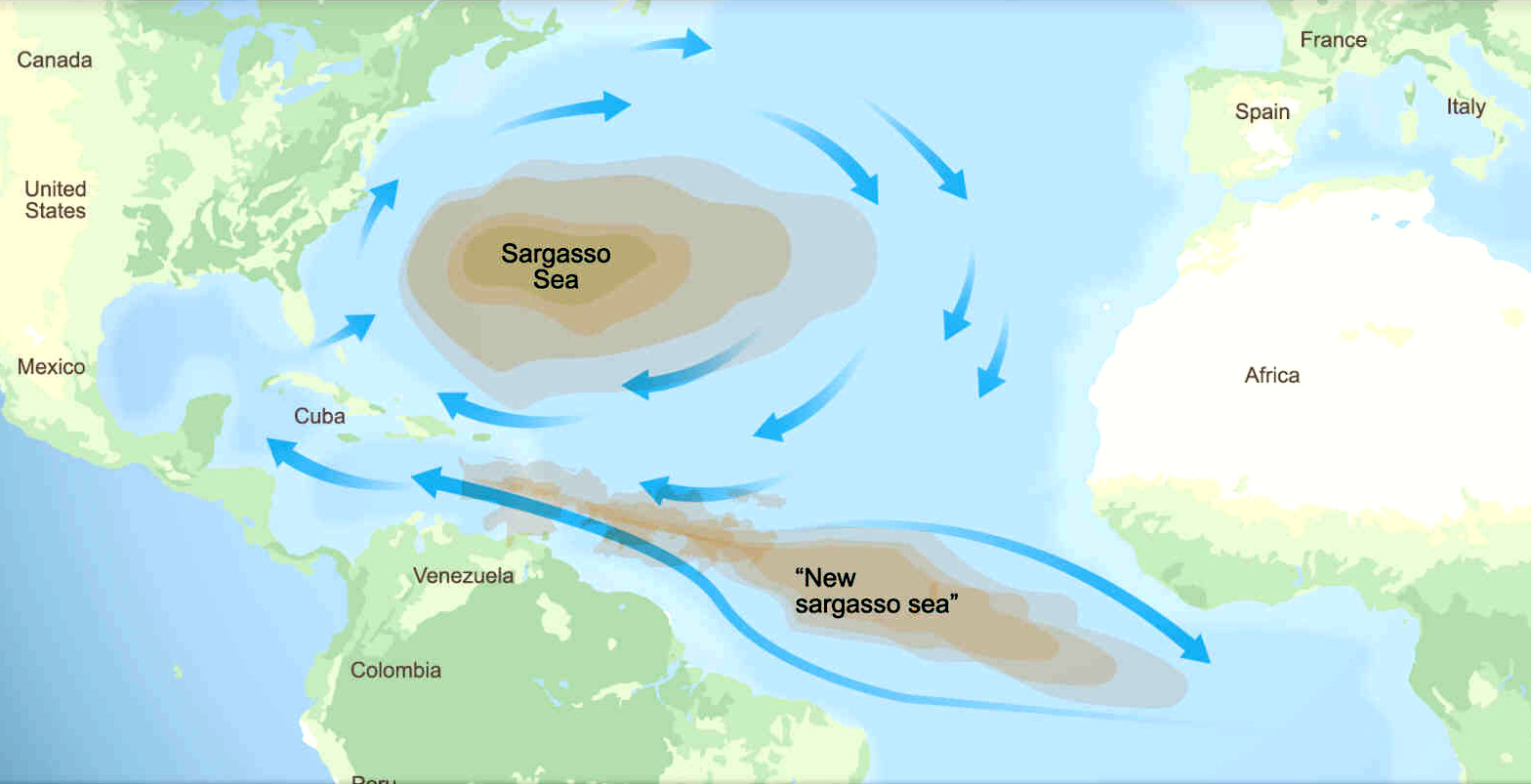
ORIGINS
OF SARGASSUM
The North Atlantic Sargasso
Sea is where sargassum originates and was contained for
hundreds of years, until climate change and intensive farming.
But should
the unthinkable happen, and the invasive species take hold in
the South Atlantic, from whence to spread it's biological
advantage,
one can imagine the dire consequences, perhaps mirroring that
now ruining the Caribbean
Sea. Make no mistake, the
consequences of climate
change and intensive, fertilizer
based farming, could
become a deadly world contagion, to make other epidemics seem insignificant,
in terms of potential human tragedy.
An
animal has a means to exhaust toxic waste, essential for a
healthy lifestyle. The oceans have nowhere to dump the
excrement we dump in it. They just get more polluted. Except
for sargassum piling onto the shores, telling us that we have
reached the limit.
So,
what are the chances of it happening? Could there be a 'South
China Sargasso Sea,' or belt, where the present welcoming waters are
turned into a cesspit
of foul smelling rotten seaweeds, as they release hydrogen
sulphide gas to choke visitors to their shores.
COMPUTER
SIMULATIONS & CONTAINMENT DEVICES
That
all depends on temperature rise of seawater, combined with
nutrient supply, and circulating currents, including winds.
All of which is measurable, for variable algorithmic computer
simulations. As has been performed on the influx to the
Caribbean Sea, via the equatorial Atlantic gyre, by scientists at the
University of South Florida in St. Petersburg's College of Marine Science,
who used NASA satellite observations to discover and document the largest bloom of macroalgae.
Others used Global Hybrid Coordinate Ocean Model surface currents (HYCOM) (Chassignet et al., 2007) and National Centers for Environmental Prediction Reanalysis
(NCEP), in their simulations.
But
nobody has yet created a computer model of a SeaVax
Calypso or Sargasso,
used in various (fleet SeaNet
formations) to determine if such a concept could control volume
escalation, before they grow to be profusely irrepressible.
Indeed such simulations may help develop such concepts in
terms of capacity and operations, that they may, or may not, contain the
crisis, preventing a worldwide state of emergency - by nipping
it in the bud.
THEORY
DEVELOPMENT
At
this stage of the formulation of his theory, the innovator is
considering the awful prospect, based on the demonstrable and
devastating spread of sargassum from the North Atlantic to the
Equatorial South Atlantic, but not yet migrating to the more
general south, due presumably, to temperatures not yet being to the
liking of the buoyant seaweed.
The
three major oceans are all interconnected via currents and
driving winds. The main barrier to migration at present, is
the temperature and level of nutrients, that is lower where
the seaweed
mats could pass from one to another. But that is by no means a
hard point, as the melting
of the polar caps indicates. We are living in changeable
times, where the unthinkable is taking place, as a pace faster
than previously supposed.
In
other words, the impossible is rapidly becoming possible. And
there is no containment system at present, to prevent that
from happening; no international coordination, or action plan.
A recipe for disaster you may think!
FACTUAL
BACKGROUND
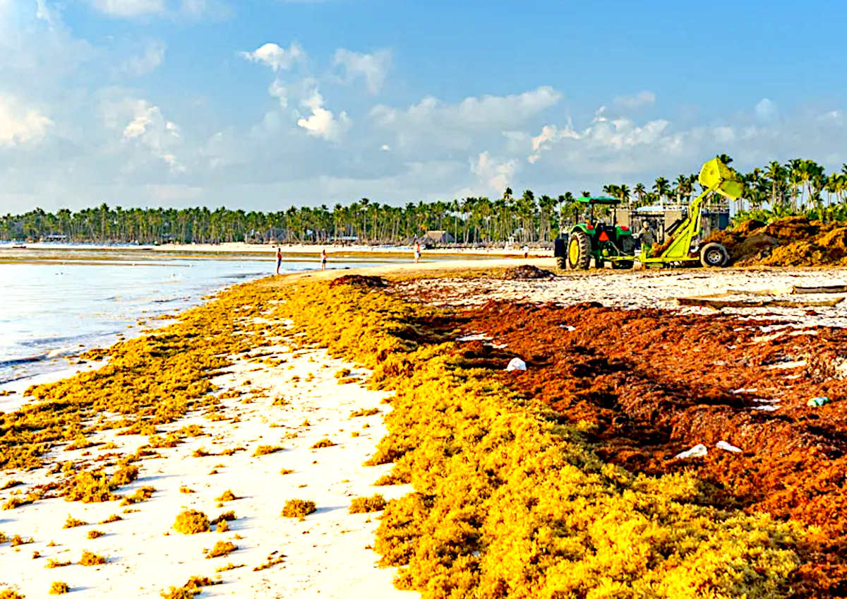
The
sargassum crisis seen in the Caribbean Sea and
Gulf of Mexico could be just the
beginning of a worldwide plague, stemming from our inability
to curb political insatiability for fossil fuels - to power failing economic strategies, based on growth, when we
have already used up the planet twice over, in sustainable
terms.
The
answer to failed political policies is very often a jolly good war,
(Russia Vs Ukraine). When all cock-ups get thrown to the wind in
the media scrum, and a whitewash ensues, until the next band of
post-war cutthroats is elected, each with their hands in the
pockets of Lucifer's climate change deniers.
That said, it would take a nuclear conflict to reduce earth's population
significantly enough to brake global warming - but then the planet
would be barren and unable to support human life. Hence, an
unthinkable solution to all but the most desperate of
homicidal kleptocrats: warmongers.
But,
ignoring thermonuclear first strikes for now, even if we
transition to renewables
immediately, global warming
will not reverse for 30-50 years at best, and that is
with a fair political wind. Meaning that the conditions for sargassum
to populate welcoming equatorial waters (rich in nutrients) around the globe,
remains a distinct possibility. Such as the:
Arabian
Sea
Atlantic
- North &
South
Equatorial
Banda
Ceram Molucca & Timor Seas
Bay
of Bengal
Celebes
Sea
Gulf
of Guinea
Gulf
of Thailand
Indian
Ocean
Java
Sea
Pacific
Ocean - North & South, Equatorial
Belt (Costa Rica, Ecuador,
Panama regions)
Philippine
Sea
South
China Sea
Seas
and oceans in these latitudes could become inundated with macro
algae, if the rafts of floating seaweed
manage to navigate
less hospitable barriers, such as colder regions. Which at the
moment, Cape Horn and the Cape
of Good Hope appear to offer some protection from
invasion.
THESIS
This
is a theory proposed by Nelson
Kay (as a volunteer) in August of 2022, based on his work with the SeaVax
team from 2016 - 2020. Though that exertion was mostly concerning
micro and
macro plastic recovery and river
containment, the ocean engineering and logistical challenges
posed by SeaVax
are kindred concepts, and may be sympathetically adapted or
even interchangeable to some degree. And may one day inspire
others to devise a practical resolution.
Academics
and scientific institutions inclined to test such thesis, or
otherwise wishing to provide data or technological assistance,
positive or negative, should please contact
the Cleaner Ocean Foundation in the first instance. The
aim being to prove or disprove the concept, to advance our
knowledge in this little understood area of Oceanology/Oceanography.
Students at all levels are most welcome, as are degree level
students and post graduates looking to higher level
qualifications, or simply to gain experience.
There
are a million reasons for not doing something, and only one for
taking up a challenge. Most people will use
manifold negatives to sit back in their
armchairs, and postulate. But, every now and again, someone is foolhardy enough to
roll their sleeves up - and experiment - because they feel they
must. Despite the enormity of
the task. And that is how this website came about, in support
of the SeaVax
project in 2017.
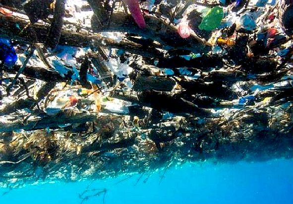
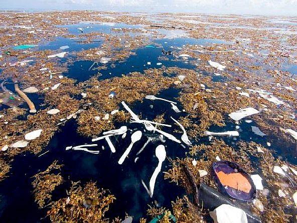
PLASTIC
TIDE - These amazing pictures of a giant plastic tide were
taken by Caroline Power. Please note how plastic and sargassum
intertwine, creating a separation problem.
CARIBBEAN
ISLANDS UNDER THREAT A-Z
Anguilla
Antigua
and Barbuda
Aruba
(Netherlands)
Bahamas
Barbados
British
Virgin Islands
Caribbean
Netherlands
Cayman
Islands (UK)
Cuba
Curaçao
(Netherlands)
Dominica
Dominican
Republic (Hispaniola)
Grenada
Guadeloupe
(France)
Haiti
(Hispaniola)
Jamaica
Martinique
(France)
Montserrat
Puerto
Rico (US)
Roatán
Saint
Barthélemy
Saint
Kitts and Nevis
Saint
Lucia
Saint
Martin
Saint
Vincent and the Grenadines
Sint
Maarten (Netherlands)
Tortuga
Trinidad
and Tobago
Turks
and Caicos Islands
United
States Virgin Islands
LINKS
& REFERENCE
https://www.researchgate.net/publication/319694631
This
website is provided on a free basis as a public information
service. copyright © Cleaner
Oceans Foundation Ltd (COFL) (Company No: 4674774)
August 2022. Solar
Studios, BN271RF, United Kingdom.
COFL
is a charity without share capital. The names Amphimax™
RiverVax™
and SeaVax™
are trademarks.
|